You are here: Home > Network List > GS - US Geological Survey Networks Stations List
> Station ASL8 Albuquerque, New Mexico, USA > Earthquake Result Viewer
ASL8 Albuquerque, New Mexico, USA - Earthquake Result Viewer
| Earthquake location: |
Northwest Of Kuril Islands |
| Earthquake latitude/longitude: |
52.7/153.7 |
| Earthquake time(UTC): |
2018/10/13 (286) 11:10:19 GMT |
| Earthquake Depth: |
397 km |
| Earthquake Magnitude: |
6.7 Mi |
| Earthquake Catalog/Contributor: |
NEIC PDE/pt |
|
| Network: |
GS US Geological Survey Networks |
| Station: |
ASL8 Albuquerque, New Mexico, USA |
| Lat/Lon: |
34.95 N/106.46 W |
| Elevation: |
1820 m |
|
| Distance: |
68.5 deg |
| Az: |
60.454 deg |
| Baz: |
319.872 deg |
| Ray Param: |
0.05500575 |
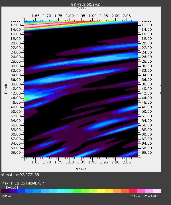
| Estimated Moho Depth: |
12.25 km |
| Estimated Crust Vp/Vs: |
1.61 |
| Assumed Crust Vp: |
6.502 km/s |
| Estimated Crust Vs: |
4.038 km/s |
| Estimated Crust Poisson's Ratio: |
0.19 |
|
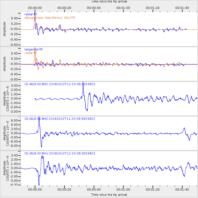
| Radial Match: |
93.073135 % |
| Radial Bump: |
345 |
| Transverse Match: |
85.926216 % |
| Transverse Bump: |
400 |
| SOD ConfigId: |
3045211 |
| Insert Time: |
2018-10-27 11:20:10.350 +0000 |
| GWidth: |
2.5 |
| Max Bumps: |
400 |
| Tol: |
0.001 |
|
Signal To Noise
| Channel | StoN | STA | LTA |
| GS:ASL8:00:BHZ:20181013T11:20:08.893982Z | 34.00228 | 5.0046183E-6 | 1.4718478E-7 |
| GS:ASL8:00:BH1:20181013T11:20:08.893982Z | 11.385455 | 1.6154723E-6 | 1.4188912E-7 |
| GS:ASL8:00:BH2:20181013T11:20:08.893982Z | 12.88384 | 1.3676738E-6 | 1.0615421E-7 |
| Arrivals |
| Ps | 1.2 SECOND |
| PpPs | 4.7 SECOND |
| PsPs/PpSs | 5.9 SECOND |


