You are here: Home > Network List > PS - Pacific21 Stations List
> Station INU Inuyama, Japan > Earthquake Result Viewer
INU Inuyama, Japan - Earthquake Result Viewer
| Earthquake location: |
Java, Indonesia |
| Earthquake latitude/longitude: |
-6.0/112.0 |
| Earthquake time(UTC): |
2023/04/14 (104) 09:55:45 GMT |
| Earthquake Depth: |
594 km |
| Earthquake Magnitude: |
7.0 mww |
| Earthquake Catalog/Contributor: |
NEIC PDE/us |
|
| Network: |
PS Pacific21 |
| Station: |
INU Inuyama, Japan |
| Lat/Lon: |
35.35 N/137.03 E |
| Elevation: |
132 m |
|
| Distance: |
47.4 deg |
| Az: |
27.984 deg |
| Baz: |
214.81 deg |
| Ray Param: |
0.06715501 |
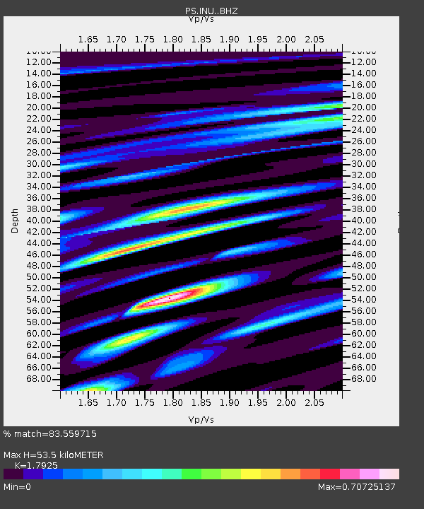
| Estimated Moho Depth: |
53.5 km |
| Estimated Crust Vp/Vs: |
1.79 |
| Assumed Crust Vp: |
6.461 km/s |
| Estimated Crust Vs: |
3.605 km/s |
| Estimated Crust Poisson's Ratio: |
0.27 |
|
| Radial Match: |
83.559715 % |
| Radial Bump: |
400 |
| Transverse Match: |
74.91018 % |
| Transverse Bump: |
400 |
| SOD ConfigId: |
30536071 |
| Insert Time: |
2023-04-28 13:11:58.691 +0000 |
| GWidth: |
2.5 |
| Max Bumps: |
400 |
| Tol: |
0.001 |
|

Signal To Noise
| Channel | StoN | STA | LTA |
| PS:INU: :BHZ:20230414T10:02:56.461014Z | 43.747185 | 5.4732423E-6 | 1.2511073E-7 |
| PS:INU: :BHN:20230414T10:02:56.461014Z | 14.399961 | 1.8955029E-6 | 1.316325E-7 |
| PS:INU: :BHE:20230414T10:02:56.461014Z | 24.008528 | 2.1215542E-6 | 8.836669E-8 |
| Arrivals |
| Ps | 6.9 SECOND |
| PpPs | 22 SECOND |
| PsPs/PpSs | 29 SECOND |


