You are here: Home > Network List > G - GEOSCOPE Stations List
> Station TAM Tamanrasset, Algeria > Earthquake Result Viewer
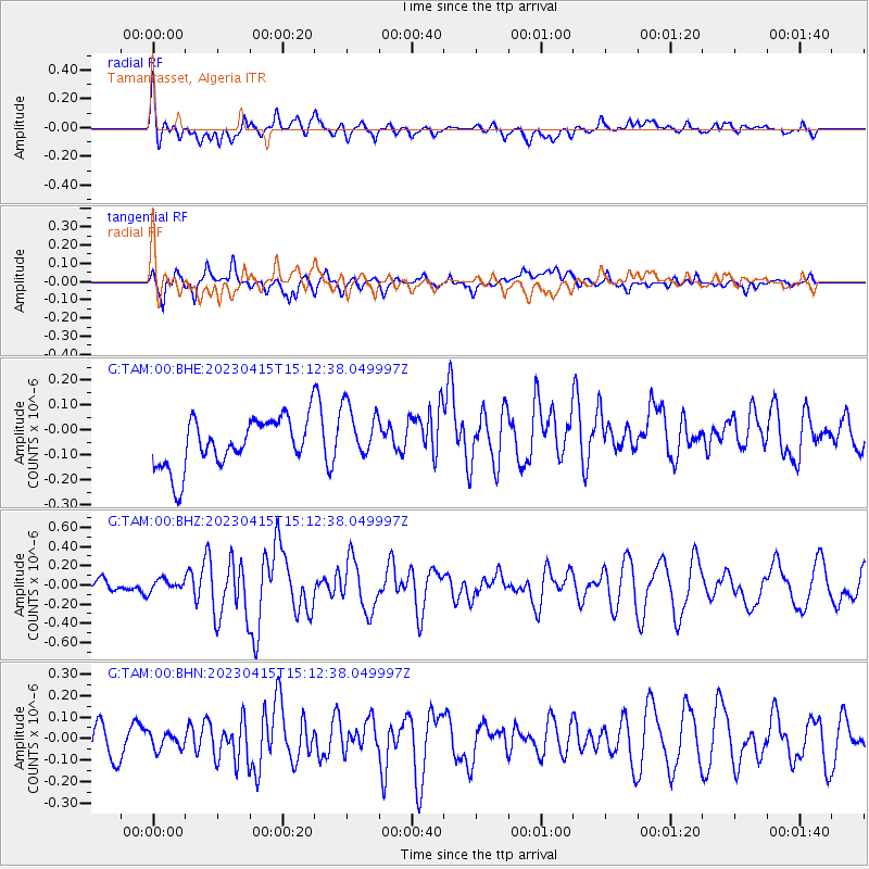
TAM Tamanrasset, Algeria - Earthquake Result Viewer
*The percent match for this event was below the threshold and hence no stack was calculated.
| Earthquake location: |
Southwest Indian Ridge |
| Earthquake latitude/longitude: |
-33.8/56.2 |
| Earthquake time(UTC): |
2023/04/15 (105) 15:01:33 GMT |
| Earthquake Depth: |
10 km |
| Earthquake Magnitude: |
5.9 Mww |
| Earthquake Catalog/Contributor: |
NEIC PDE/us |
|
| Network: |
G GEOSCOPE |
| Station: |
TAM Tamanrasset, Algeria |
| Lat/Lon: |
22.79 N/5.53 E |
| Elevation: |
1377 m |
|
| Distance: |
74.1 deg |
| Az: |
312.082 deg |
| Baz: |
137.929 deg |
| Ray Param: |
$rayparam |
*The percent match for this event was below the threshold and hence was not used in the summary stack. |
|
| Radial Match: |
60.643635 % |
| Radial Bump: |
400 |
| Transverse Match: |
59.712826 % |
| Transverse Bump: |
400 |
| SOD ConfigId: |
30536071 |
| Insert Time: |
2023-04-29 15:04:33.737 +0000 |
| GWidth: |
2.5 |
| Max Bumps: |
400 |
| Tol: |
0.001 |
|
Signal To Noise
| Channel | StoN | STA | LTA |
| G:TAM:00:BHZ:20230415T15:12:38.049997Z | 0.8736524 | 6.197838E-8 | 7.0941695E-8 |
| G:TAM:00:BHN:20230415T15:12:38.049997Z | 0.5387578 | 3.7858456E-8 | 7.0269905E-8 |
| G:TAM:00:BHE:20230415T15:12:38.049997Z | 1.1560241 | 1.1280038E-7 | 9.757615E-8 |
| Arrivals |
| Ps | |
| PpPs | |
| PsPs/PpSs | |


