You are here: Home > Network List > GS - US Geological Survey Networks Stations List
> Station KAN10 Keim Farm > Earthquake Result Viewer
KAN10 Keim Farm - Earthquake Result Viewer

| Earthquake location: |
Northwest Of Kuril Islands |
| Earthquake latitude/longitude: |
52.7/153.7 |
| Earthquake time(UTC): |
2018/10/13 (286) 11:10:19 GMT |
| Earthquake Depth: |
397 km |
| Earthquake Magnitude: |
6.7 Mi |
| Earthquake Catalog/Contributor: |
NEIC PDE/pt |
|
| Network: |
GS US Geological Survey Networks |
| Station: |
KAN10 Keim Farm |
| Lat/Lon: |
37.12 N/98.10 W |
| Elevation: |
417 m |
|
| Distance: |
71.1 deg |
| Az: |
53.383 deg |
| Baz: |
322.327 deg |
| Ray Param: |
0.053356547 |
| Estimated Moho Depth: |
36.75 km |
| Estimated Crust Vp/Vs: |
1.82 |
| Assumed Crust Vp: |
6.426 km/s |
| Estimated Crust Vs: |
3.531 km/s |
| Estimated Crust Poisson's Ratio: |
0.28 |
|
| Radial Match: |
99.239204 % |
| Radial Bump: |
62 |
| Transverse Match: |
98.941246 % |
| Transverse Bump: |
64 |
| SOD ConfigId: |
3045211 |
| Insert Time: |
2018-10-27 11:20:31.387 +0000 |
| GWidth: |
2.5 |
| Max Bumps: |
400 |
| Tol: |
0.001 |
|
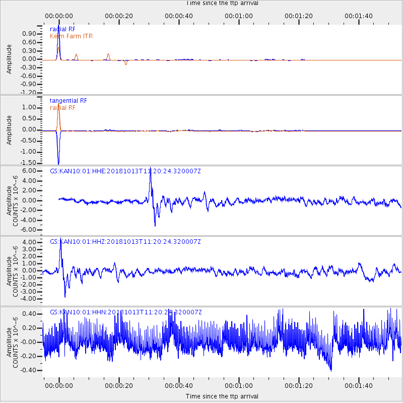
Signal To Noise
| Channel | StoN | STA | LTA |
| GS:KAN10:01:HHZ:20181013T11:20:24.320007Z | 8.614219 | 1.758087E-6 | 2.0409128E-7 |
| GS:KAN10:01:HHN:20181013T11:20:24.320007Z | 0.96100116 | 1.347519E-7 | 1.4022034E-7 |
| GS:KAN10:01:HHE:20181013T11:20:24.320007Z | 9.008703 | 2.5129807E-6 | 2.789503E-7 |
| Arrivals |
| Ps | 4.8 SECOND |
| PpPs | 16 SECOND |
| PsPs/PpSs | 20 SECOND |


