You are here: Home > Network List > CI - Caltech Regional Seismic Network Stations List
> Station FUR Furnace Creek, CA, USA > Earthquake Result Viewer
FUR Furnace Creek, CA, USA - Earthquake Result Viewer
| Earthquake location: |
Vanuatu Islands |
| Earthquake latitude/longitude: |
-13.6/167.2 |
| Earthquake time(UTC): |
2010/03/04 (063) 14:02:27 GMT |
| Earthquake Depth: |
176 km |
| Earthquake Magnitude: |
6.0 MB, 6.5 MW, 6.4 MW |
| Earthquake Catalog/Contributor: |
WHDF/NEIC |
|
| Network: |
CI Caltech Regional Seismic Network |
| Station: |
FUR Furnace Creek, CA, USA |
| Lat/Lon: |
36.47 N/116.86 W |
| Elevation: |
-37.0 m |
|
| Distance: |
87.0 deg |
| Az: |
51.531 deg |
| Baz: |
250.822 deg |
| Ray Param: |
0.043265235 |
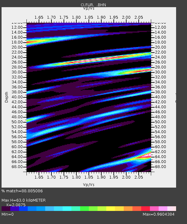
| Estimated Moho Depth: |
63.0 km |
| Estimated Crust Vp/Vs: |
2.09 |
| Assumed Crust Vp: |
6.279 km/s |
| Estimated Crust Vs: |
3.008 km/s |
| Estimated Crust Poisson's Ratio: |
0.35 |
|
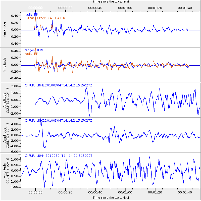
| Radial Match: |
88.885086 % |
| Radial Bump: |
400 |
| Transverse Match: |
79.56938 % |
| Transverse Bump: |
400 |
| SOD ConfigId: |
308276 |
| Insert Time: |
2010-06-22 16:06:46.912 +0000 |
| GWidth: |
2.5 |
| Max Bumps: |
400 |
| Tol: |
0.001 |
|
Signal To Noise
| Channel | StoN | STA | LTA |
| CI:FUR: :BHZ:20100304T14:14:21.515027Z | 8.421255 | 2.3535986E-6 | 2.794831E-7 |
| CI:FUR: :BHN:20100304T14:14:21.515027Z | 1.5930728 | 3.4776494E-7 | 2.1829821E-7 |
| CI:FUR: :BHE:20100304T14:14:21.515027Z | 2.79868 | 8.4057996E-7 | 3.003487E-7 |
| Arrivals |
| Ps | 11 SECOND |
| PpPs | 30 SECOND |
| PsPs/PpSs | 42 SECOND |


