You are here: Home > Network List > GS - US Geological Survey Networks Stations List
> Station KS21 NEIC Portable/Temp deployment > Earthquake Result Viewer
KS21 NEIC Portable/Temp deployment - Earthquake Result Viewer
| Earthquake location: |
Northwest Of Kuril Islands |
| Earthquake latitude/longitude: |
52.7/153.7 |
| Earthquake time(UTC): |
2018/10/13 (286) 11:10:19 GMT |
| Earthquake Depth: |
397 km |
| Earthquake Magnitude: |
6.7 Mi |
| Earthquake Catalog/Contributor: |
NEIC PDE/pt |
|
| Network: |
GS US Geological Survey Networks |
| Station: |
KS21 NEIC Portable/Temp deployment |
| Lat/Lon: |
37.29 N/97.66 W |
| Elevation: |
414 m |
|
| Distance: |
71.1 deg |
| Az: |
52.989 deg |
| Baz: |
322.46 deg |
| Ray Param: |
0.05330454 |
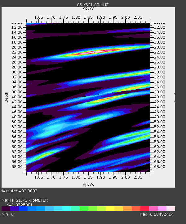
| Estimated Moho Depth: |
21.75 km |
| Estimated Crust Vp/Vs: |
1.87 |
| Assumed Crust Vp: |
6.483 km/s |
| Estimated Crust Vs: |
3.462 km/s |
| Estimated Crust Poisson's Ratio: |
0.30 |
|
| Radial Match: |
83.0097 % |
| Radial Bump: |
300 |
| Transverse Match: |
52.35745 % |
| Transverse Bump: |
355 |
| SOD ConfigId: |
3045211 |
| Insert Time: |
2018-10-27 11:20:40.510 +0000 |
| GWidth: |
2.5 |
| Max Bumps: |
400 |
| Tol: |
0.001 |
|

Signal To Noise
| Channel | StoN | STA | LTA |
| GS:KS21:00:HHZ:20181013T11:20:24.804016Z | 18.161934 | 4.675343E-6 | 2.574254E-7 |
| GS:KS21:00:HH1:20181013T11:20:24.804016Z | 6.4747205 | 1.7864173E-6 | 2.7590647E-7 |
| GS:KS21:00:HH2:20181013T11:20:24.804016Z | 4.893796 | 1.2756924E-6 | 2.6067542E-7 |
| Arrivals |
| Ps | 3.0 SECOND |
| PpPs | 9.3 SECOND |
| PsPs/PpSs | 12 SECOND |


