You are here: Home > Network List > GS - US Geological Survey Networks Stations List
> Station OK031 S. Brethren Rd., Cushing, OK, USA > Earthquake Result Viewer
OK031 S. Brethren Rd., Cushing, OK, USA - Earthquake Result Viewer
| Earthquake location: |
Northwest Of Kuril Islands |
| Earthquake latitude/longitude: |
52.7/153.7 |
| Earthquake time(UTC): |
2018/10/13 (286) 11:10:19 GMT |
| Earthquake Depth: |
397 km |
| Earthquake Magnitude: |
6.7 Mi |
| Earthquake Catalog/Contributor: |
NEIC PDE/pt |
|
| Network: |
GS US Geological Survey Networks |
| Station: |
OK031 S. Brethren Rd., Cushing, OK, USA |
| Lat/Lon: |
35.95 N/96.84 W |
| Elevation: |
290 m |
|
| Distance: |
72.6 deg |
| Az: |
53.282 deg |
| Baz: |
323.04 deg |
| Ray Param: |
0.052359264 |
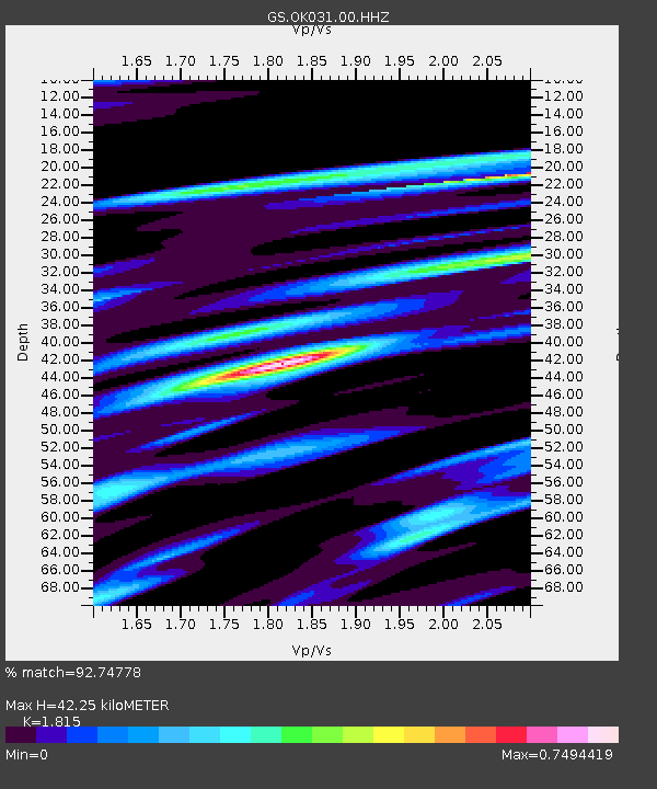
| Estimated Moho Depth: |
42.25 km |
| Estimated Crust Vp/Vs: |
1.82 |
| Assumed Crust Vp: |
6.426 km/s |
| Estimated Crust Vs: |
3.541 km/s |
| Estimated Crust Poisson's Ratio: |
0.28 |
|
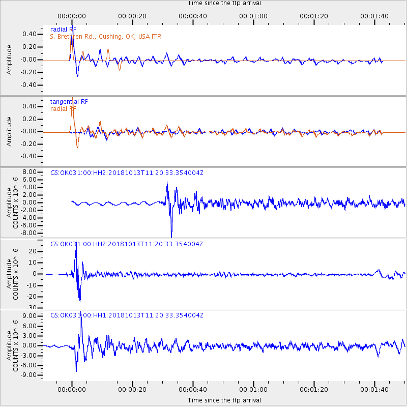
| Radial Match: |
92.74778 % |
| Radial Bump: |
275 |
| Transverse Match: |
75.239136 % |
| Transverse Bump: |
400 |
| SOD ConfigId: |
3045211 |
| Insert Time: |
2018-10-27 11:20:46.681 +0000 |
| GWidth: |
2.5 |
| Max Bumps: |
400 |
| Tol: |
0.001 |
|
Signal To Noise
| Channel | StoN | STA | LTA |
| GS:OK031:00:HHZ:20181013T11:20:33.354004Z | 43.00219 | 1.0300001E-5 | 2.395227E-7 |
| GS:OK031:00:HH1:20181013T11:20:33.354004Z | 18.925259 | 3.890774E-6 | 2.0558633E-7 |
| GS:OK031:00:HH2:20181013T11:20:33.354004Z | 10.340527 | 2.9969428E-6 | 2.8982498E-7 |
| Arrivals |
| Ps | 5.5 SECOND |
| PpPs | 18 SECOND |
| PsPs/PpSs | 23 SECOND |


