You are here: Home > Network List > AV - Alaska Volcano Observatory Stations List
> Station CESW Southwest, Cerberus Volcano, Alaska > Earthquake Result Viewer
CESW Southwest, Cerberus Volcano, Alaska - Earthquake Result Viewer
| Earthquake location: |
Southern Sumatra, Indonesia |
| Earthquake latitude/longitude: |
-4.9/103.0 |
| Earthquake time(UTC): |
2023/04/17 (107) 11:05:55 GMT |
| Earthquake Depth: |
58 km |
| Earthquake Magnitude: |
5.5 mb |
| Earthquake Catalog/Contributor: |
NEIC PDE/us |
|
| Network: |
AV Alaska Volcano Observatory |
| Station: |
CESW Southwest, Cerberus Volcano, Alaska |
| Lat/Lon: |
51.90 N/179.56 E |
| Elevation: |
238 m |
|
| Distance: |
85.6 deg |
| Az: |
37.195 deg |
| Baz: |
256.449 deg |
| Ray Param: |
0.04453493 |
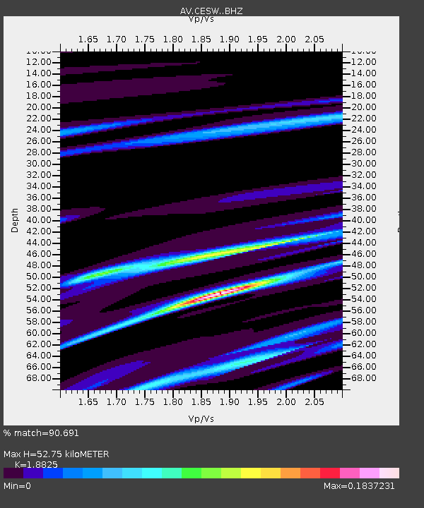
| Estimated Moho Depth: |
52.75 km |
| Estimated Crust Vp/Vs: |
1.88 |
| Assumed Crust Vp: |
6.183 km/s |
| Estimated Crust Vs: |
3.284 km/s |
| Estimated Crust Poisson's Ratio: |
0.30 |
|
| Radial Match: |
90.691 % |
| Radial Bump: |
156 |
| Transverse Match: |
90.72117 % |
| Transverse Bump: |
164 |
| SOD ConfigId: |
30536071 |
| Insert Time: |
2023-05-01 11:08:32.353 +0000 |
| GWidth: |
2.5 |
| Max Bumps: |
400 |
| Tol: |
0.001 |
|

Signal To Noise
| Channel | StoN | STA | LTA |
| AV:CESW: :BHZ:20230417T11:17:56.460023Z | 0.9729626 | 1.1968313E-5 | 1.2300896E-5 |
| AV:CESW: :BHN:20230417T11:17:56.460023Z | 0.92824066 | 1.8554512E-5 | 1.9988904E-5 |
| AV:CESW: :BHE:20230417T11:17:56.460023Z | 0.9278973 | 1.7335871E-8 | 1.8682963E-8 |
| Arrivals |
| Ps | 7.7 SECOND |
| PpPs | 24 SECOND |
| PsPs/PpSs | 32 SECOND |


