You are here: Home > Network List > IU - Global Seismograph Network (GSN - IRIS/USGS) Stations List
> Station PMG Port Moresby, New Guinea > Earthquake Result Viewer
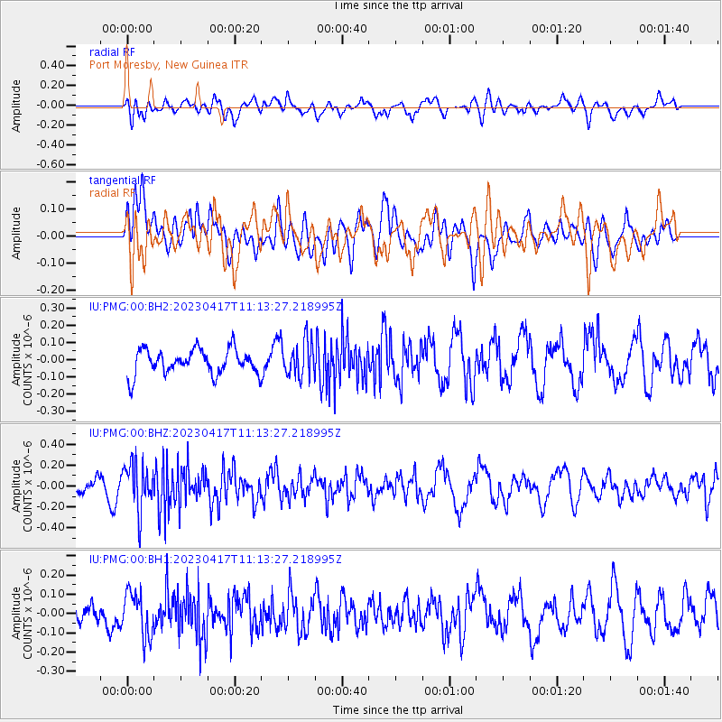
PMG Port Moresby, New Guinea - Earthquake Result Viewer
*The percent match for this event was below the threshold and hence no stack was calculated.
| Earthquake location: |
Southern Sumatra, Indonesia |
| Earthquake latitude/longitude: |
-4.9/103.0 |
| Earthquake time(UTC): |
2023/04/17 (107) 11:05:55 GMT |
| Earthquake Depth: |
58 km |
| Earthquake Magnitude: |
5.5 mb |
| Earthquake Catalog/Contributor: |
NEIC PDE/us |
|
| Network: |
IU Global Seismograph Network (GSN - IRIS/USGS) |
| Station: |
PMG Port Moresby, New Guinea |
| Lat/Lon: |
9.40 S/147.16 E |
| Elevation: |
90 m |
|
| Distance: |
44.1 deg |
| Az: |
98.421 deg |
| Baz: |
272.669 deg |
| Ray Param: |
$rayparam |
*The percent match for this event was below the threshold and hence was not used in the summary stack. |
|
| Radial Match: |
52.44464 % |
| Radial Bump: |
400 |
| Transverse Match: |
50.633644 % |
| Transverse Bump: |
400 |
| SOD ConfigId: |
30536071 |
| Insert Time: |
2023-05-01 11:11:10.945 +0000 |
| GWidth: |
2.5 |
| Max Bumps: |
400 |
| Tol: |
0.001 |
|
Signal To Noise
| Channel | StoN | STA | LTA |
| IU:PMG:00:BHZ:20230417T11:13:27.218995Z | 2.31528 | 2.2770838E-7 | 9.8350256E-8 |
| IU:PMG:00:BH1:20230417T11:13:27.218995Z | 2.0961592 | 1.1557156E-7 | 5.5134915E-8 |
| IU:PMG:00:BH2:20230417T11:13:27.218995Z | 1.413694 | 1.0307902E-7 | 7.291465E-8 |
| Arrivals |
| Ps | |
| PpPs | |
| PsPs/PpSs | |


