You are here: Home > Network List > IU - Global Seismograph Network (GSN - IRIS/USGS) Stations List
> Station HKT Hockley, Texas > Earthquake Result Viewer
HKT Hockley, Texas - Earthquake Result Viewer
| Earthquake location: |
Northwest Of Kuril Islands |
| Earthquake latitude/longitude: |
52.7/153.7 |
| Earthquake time(UTC): |
2018/10/13 (286) 11:10:19 GMT |
| Earthquake Depth: |
397 km |
| Earthquake Magnitude: |
6.7 Mi |
| Earthquake Catalog/Contributor: |
NEIC PDE/pt |
|
| Network: |
IU Global Seismograph Network (GSN - IRIS/USGS) |
| Station: |
HKT Hockley, Texas |
| Lat/Lon: |
29.96 N/95.84 W |
| Elevation: |
69 m |
|
| Distance: |
77.9 deg |
| Az: |
56.236 deg |
| Baz: |
324.336 deg |
| Ray Param: |
0.04887443 |
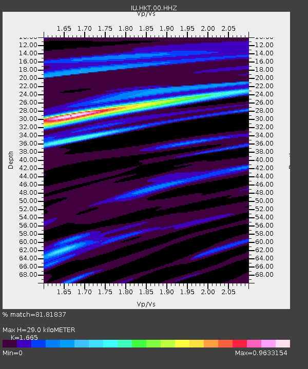
| Estimated Moho Depth: |
29.0 km |
| Estimated Crust Vp/Vs: |
1.66 |
| Assumed Crust Vp: |
5.581 km/s |
| Estimated Crust Vs: |
3.352 km/s |
| Estimated Crust Poisson's Ratio: |
0.22 |
|
| Radial Match: |
81.81837 % |
| Radial Bump: |
283 |
| Transverse Match: |
69.69182 % |
| Transverse Bump: |
400 |
| SOD ConfigId: |
3045211 |
| Insert Time: |
2018-10-27 11:21:34.480 +0000 |
| GWidth: |
2.5 |
| Max Bumps: |
400 |
| Tol: |
0.001 |
|
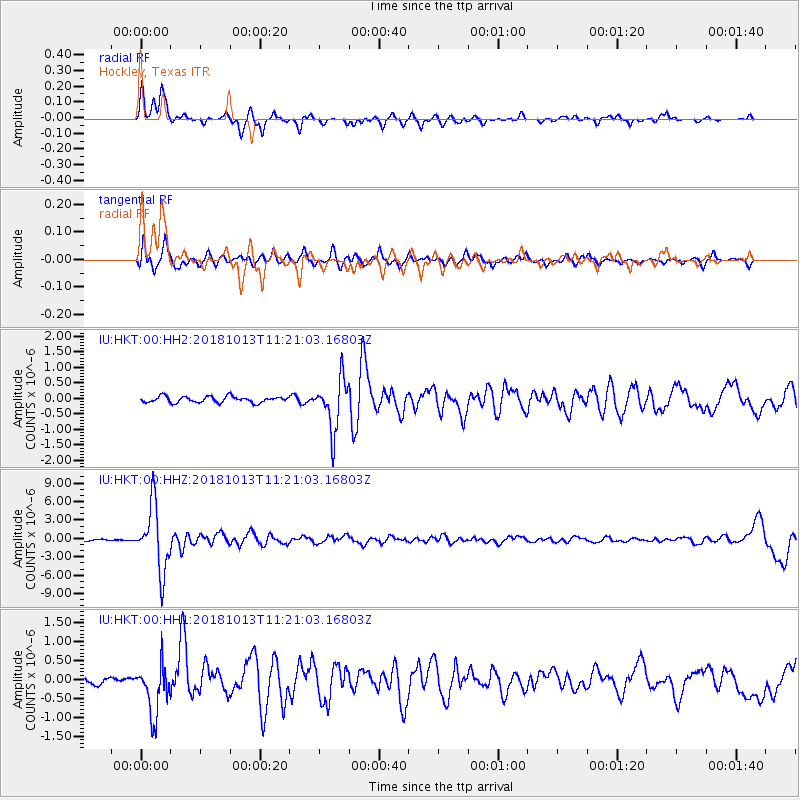
Signal To Noise
| Channel | StoN | STA | LTA |
| IU:HKT:00:HHZ:20181013T11:21:03.16803Z | 31.622078 | 5.287673E-6 | 1.672146E-7 |
| IU:HKT:00:HH1:20181013T11:21:03.16803Z | 4.249505 | 6.7308616E-7 | 1.5839167E-7 |
| IU:HKT:00:HH2:20181013T11:21:03.16803Z | 8.330701 | 8.167471E-7 | 9.804062E-8 |
| Arrivals |
| Ps | 3.5 SECOND |
| PpPs | 14 SECOND |
| PsPs/PpSs | 17 SECOND |


