You are here: Home > Network List > IU - Global Seismograph Network (GSN - IRIS/USGS) Stations List
> Station KONO Kongsberg, Norway > Earthquake Result Viewer
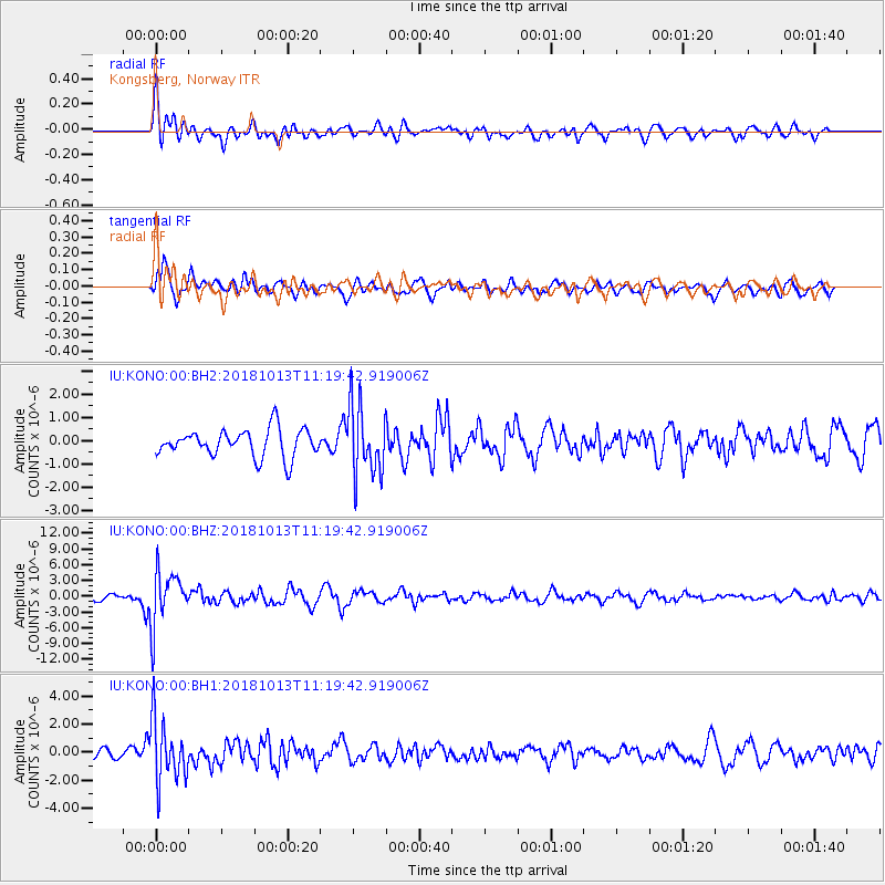
KONO Kongsberg, Norway - Earthquake Result Viewer
*The percent match for this event was below the threshold and hence no stack was calculated.
| Earthquake location: |
Northwest Of Kuril Islands |
| Earthquake latitude/longitude: |
52.7/153.7 |
| Earthquake time(UTC): |
2018/10/13 (286) 11:10:19 GMT |
| Earthquake Depth: |
397 km |
| Earthquake Magnitude: |
6.7 Mi |
| Earthquake Catalog/Contributor: |
NEIC PDE/pt |
|
| Network: |
IU Global Seismograph Network (GSN - IRIS/USGS) |
| Station: |
KONO Kongsberg, Norway |
| Lat/Lon: |
59.65 N/9.60 E |
| Elevation: |
216 m |
|
| Distance: |
64.3 deg |
| Az: |
340.695 deg |
| Baz: |
23.34 deg |
| Ray Param: |
$rayparam |
*The percent match for this event was below the threshold and hence was not used in the summary stack. |
|
| Radial Match: |
71.048195 % |
| Radial Bump: |
400 |
| Transverse Match: |
74.53909 % |
| Transverse Bump: |
400 |
| SOD ConfigId: |
3045211 |
| Insert Time: |
2018-10-27 11:21:41.155 +0000 |
| GWidth: |
2.5 |
| Max Bumps: |
400 |
| Tol: |
0.001 |
|
Signal To Noise
| Channel | StoN | STA | LTA |
| IU:KONO:00:BHZ:20181013T11:19:42.919006Z | 7.4530973 | 5.0686485E-6 | 6.8007273E-7 |
| IU:KONO:00:BH1:20181013T11:19:42.919006Z | 6.2756104 | 2.2048912E-6 | 3.513429E-7 |
| IU:KONO:00:BH2:20181013T11:19:42.919006Z | 2.5513446 | 1.5080458E-6 | 5.910788E-7 |
| Arrivals |
| Ps | |
| PpPs | |
| PsPs/PpSs | |


