You are here: Home > Network List > IW - Intermountain West Stations List
> Station IMW Indian Meadow, Wyoming, USA > Earthquake Result Viewer
IMW Indian Meadow, Wyoming, USA - Earthquake Result Viewer

| Earthquake location: |
Northwest Of Kuril Islands |
| Earthquake latitude/longitude: |
52.7/153.7 |
| Earthquake time(UTC): |
2018/10/13 (286) 11:10:19 GMT |
| Earthquake Depth: |
397 km |
| Earthquake Magnitude: |
6.7 Mi |
| Earthquake Catalog/Contributor: |
NEIC PDE/pt |
|
| Network: |
IW Intermountain West |
| Station: |
IMW Indian Meadow, Wyoming, USA |
| Lat/Lon: |
43.90 N/110.94 W |
| Elevation: |
2646 m |
|
| Distance: |
59.5 deg |
| Az: |
56.612 deg |
| Baz: |
315.338 deg |
| Ray Param: |
0.0606886 |
| Estimated Moho Depth: |
69.25 km |
| Estimated Crust Vp/Vs: |
1.81 |
| Assumed Crust Vp: |
6.207 km/s |
| Estimated Crust Vs: |
3.439 km/s |
| Estimated Crust Poisson's Ratio: |
0.28 |
|
| Radial Match: |
94.25944 % |
| Radial Bump: |
400 |
| Transverse Match: |
88.38814 % |
| Transverse Bump: |
400 |
| SOD ConfigId: |
3045211 |
| Insert Time: |
2018-10-27 11:22:07.251 +0000 |
| GWidth: |
2.5 |
| Max Bumps: |
400 |
| Tol: |
0.001 |
|
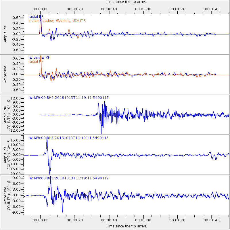
Signal To Noise
| Channel | StoN | STA | LTA |
| IW:IMW:00:BHZ:20181013T11:19:11.549011Z | 41.000114 | 5.6183244E-6 | 1.3703193E-7 |
| IW:IMW:00:BH1:20181013T11:19:11.549011Z | 15.311551 | 2.0061157E-6 | 1.3101976E-7 |
| IW:IMW:00:BH2:20181013T11:19:11.549011Z | 21.200281 | 2.5523773E-6 | 1.2039357E-7 |
| Arrivals |
| Ps | 9.4 SECOND |
| PpPs | 30 SECOND |
| PsPs/PpSs | 39 SECOND |


