You are here: Home > Network List > NM - Cooperative New Madrid Seismic Network Stations List
> Station CLTN Cedars of Lebanon,TN > Earthquake Result Viewer
CLTN Cedars of Lebanon,TN - Earthquake Result Viewer
| Earthquake location: |
Northwest Of Kuril Islands |
| Earthquake latitude/longitude: |
52.7/153.7 |
| Earthquake time(UTC): |
2018/10/13 (286) 11:10:19 GMT |
| Earthquake Depth: |
397 km |
| Earthquake Magnitude: |
6.7 Mi |
| Earthquake Catalog/Contributor: |
NEIC PDE/pt |
|
| Network: |
NM Cooperative New Madrid Seismic Network |
| Station: |
CLTN Cedars of Lebanon,TN |
| Lat/Lon: |
36.09 N/86.33 W |
| Elevation: |
208 m |
|
| Distance: |
77.4 deg |
| Az: |
45.966 deg |
| Baz: |
327.303 deg |
| Ray Param: |
0.049244575 |
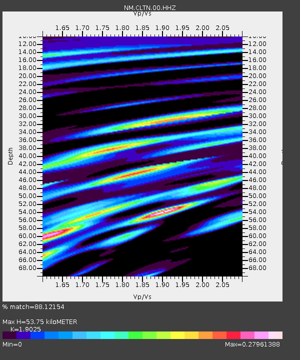
| Estimated Moho Depth: |
53.75 km |
| Estimated Crust Vp/Vs: |
1.90 |
| Assumed Crust Vp: |
6.444 km/s |
| Estimated Crust Vs: |
3.387 km/s |
| Estimated Crust Poisson's Ratio: |
0.31 |
|
| Radial Match: |
88.12154 % |
| Radial Bump: |
268 |
| Transverse Match: |
64.68616 % |
| Transverse Bump: |
345 |
| SOD ConfigId: |
3045211 |
| Insert Time: |
2018-10-27 11:22:51.340 +0000 |
| GWidth: |
2.5 |
| Max Bumps: |
400 |
| Tol: |
0.001 |
|

Signal To Noise
| Channel | StoN | STA | LTA |
| NM:CLTN:00:HHZ:20181013T11:21:00.14502Z | 22.17845 | 2.6006737E-6 | 1.17261294E-7 |
| NM:CLTN:00:HHN:20181013T11:21:00.14502Z | 7.9930167 | 8.712558E-7 | 1.0900212E-7 |
| NM:CLTN:00:HHE:20181013T11:21:00.14502Z | 6.467509 | 5.280792E-7 | 8.16511E-8 |
| Arrivals |
| Ps | 7.7 SECOND |
| PpPs | 24 SECOND |
| PsPs/PpSs | 31 SECOND |


