You are here: Home > Network List > TA - USArray Transportable Network (new EarthScope stations) Stations List
> Station 113A Mohawk Valley, Roll, AZ, USA > Earthquake Result Viewer
113A Mohawk Valley, Roll, AZ, USA - Earthquake Result Viewer
| Earthquake location: |
Vanuatu Islands |
| Earthquake latitude/longitude: |
-13.6/167.2 |
| Earthquake time(UTC): |
2010/03/04 (063) 14:02:27 GMT |
| Earthquake Depth: |
176 km |
| Earthquake Magnitude: |
6.0 MB, 6.5 MW, 6.4 MW |
| Earthquake Catalog/Contributor: |
WHDF/NEIC |
|
| Network: |
TA USArray Transportable Network (new EarthScope stations) |
| Station: |
113A Mohawk Valley, Roll, AZ, USA |
| Lat/Lon: |
32.77 N/113.77 W |
| Elevation: |
118 m |
|
| Distance: |
88.2 deg |
| Az: |
55.837 deg |
| Baz: |
252.754 deg |
| Ray Param: |
0.04232827 |
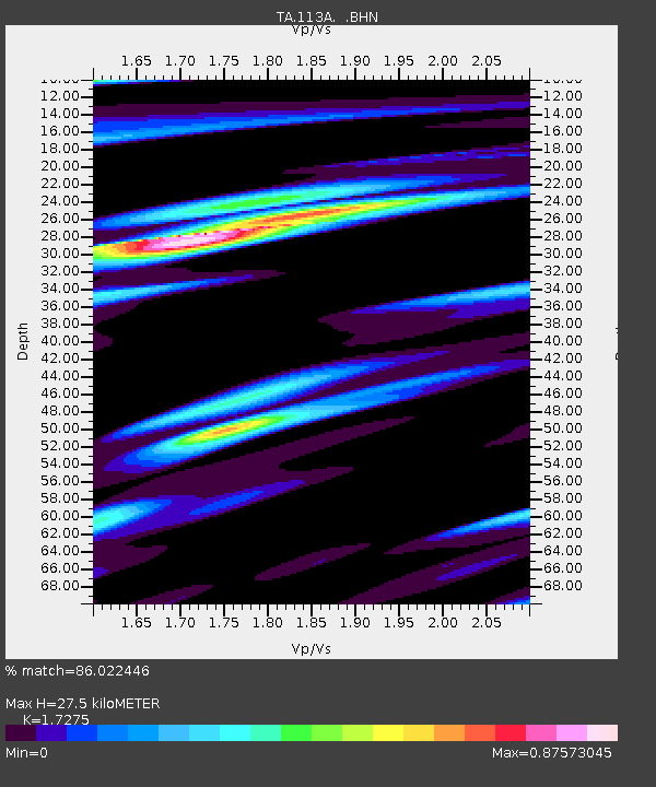
| Estimated Moho Depth: |
27.5 km |
| Estimated Crust Vp/Vs: |
1.73 |
| Assumed Crust Vp: |
6.264 km/s |
| Estimated Crust Vs: |
3.626 km/s |
| Estimated Crust Poisson's Ratio: |
0.25 |
|
| Radial Match: |
86.022446 % |
| Radial Bump: |
400 |
| Transverse Match: |
55.794064 % |
| Transverse Bump: |
351 |
| SOD ConfigId: |
308276 |
| Insert Time: |
2010-06-22 16:15:50.462 +0000 |
| GWidth: |
2.5 |
| Max Bumps: |
400 |
| Tol: |
0.001 |
|
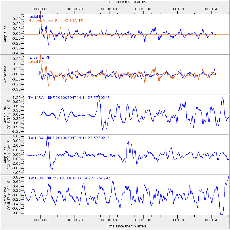
Signal To Noise
| Channel | StoN | STA | LTA |
| TA:113A: :BHZ:20100304T14:14:27.575024Z | 13.604789 | 1.7279925E-6 | 1.2701355E-7 |
| TA:113A: :BHN:20100304T14:14:27.575024Z | 1.0036104 | 2.0301954E-7 | 2.022892E-7 |
| TA:113A: :BHE:20100304T14:14:27.575024Z | 3.20101 | 5.942661E-7 | 1.8564957E-7 |
| Arrivals |
| Ps | 3.3 SECOND |
| PpPs | 12 SECOND |
| PsPs/PpSs | 15 SECOND |


