You are here: Home > Network List > NM - Cooperative New Madrid Seismic Network Stations List
> Station HBAR Harrisburg,AR(CERI) > Earthquake Result Viewer
HBAR Harrisburg,AR(CERI) - Earthquake Result Viewer
| Earthquake location: |
Northwest Of Kuril Islands |
| Earthquake latitude/longitude: |
52.7/153.7 |
| Earthquake time(UTC): |
2018/10/13 (286) 11:10:19 GMT |
| Earthquake Depth: |
397 km |
| Earthquake Magnitude: |
6.7 Mi |
| Earthquake Catalog/Contributor: |
NEIC PDE/pt |
|
| Network: |
NM Cooperative New Madrid Seismic Network |
| Station: |
HBAR Harrisburg,AR(CERI) |
| Lat/Lon: |
35.56 N/90.66 W |
| Elevation: |
74 m |
|
| Distance: |
75.9 deg |
| Az: |
49.28 deg |
| Baz: |
325.55 deg |
| Ray Param: |
0.05023502 |
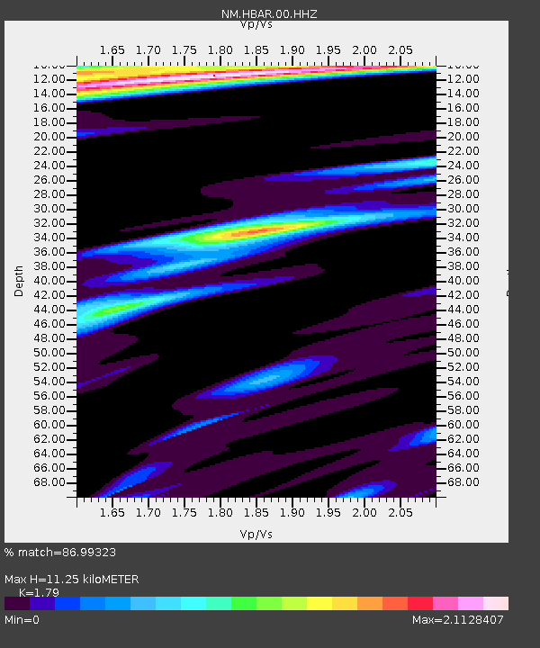
| Estimated Moho Depth: |
11.25 km |
| Estimated Crust Vp/Vs: |
1.79 |
| Assumed Crust Vp: |
6.273 km/s |
| Estimated Crust Vs: |
3.505 km/s |
| Estimated Crust Poisson's Ratio: |
0.27 |
|
| Radial Match: |
86.99323 % |
| Radial Bump: |
355 |
| Transverse Match: |
76.74013 % |
| Transverse Bump: |
396 |
| SOD ConfigId: |
3045211 |
| Insert Time: |
2018-10-27 11:22:58.994 +0000 |
| GWidth: |
2.5 |
| Max Bumps: |
400 |
| Tol: |
0.001 |
|

Signal To Noise
| Channel | StoN | STA | LTA |
| NM:HBAR:00:HHZ:20181013T11:20:51.875Z | 36.690804 | 9.65337E-6 | 2.6310053E-7 |
| NM:HBAR:00:HHN:20181013T11:20:51.875Z | 6.50171 | 4.7766016E-6 | 7.3466856E-7 |
| NM:HBAR:00:HHE:20181013T11:20:51.875Z | 3.7795646 | 3.5295902E-6 | 9.338616E-7 |
| Arrivals |
| Ps | 1.5 SECOND |
| PpPs | 4.9 SECOND |
| PsPs/PpSs | 6.3 SECOND |


