You are here: Home > Network List > NM - Cooperative New Madrid Seismic Network Stations List
> Station HENM Henderson Mound,MO > Earthquake Result Viewer
HENM Henderson Mound,MO - Earthquake Result Viewer
| Earthquake location: |
Northwest Of Kuril Islands |
| Earthquake latitude/longitude: |
52.7/153.7 |
| Earthquake time(UTC): |
2018/10/13 (286) 11:10:19 GMT |
| Earthquake Depth: |
397 km |
| Earthquake Magnitude: |
6.7 Mi |
| Earthquake Catalog/Contributor: |
NEIC PDE/pt |
|
| Network: |
NM Cooperative New Madrid Seismic Network |
| Station: |
HENM Henderson Mound,MO |
| Lat/Lon: |
36.72 N/89.47 W |
| Elevation: |
88 m |
|
| Distance: |
75.4 deg |
| Az: |
47.789 deg |
| Baz: |
325.876 deg |
| Ray Param: |
0.05050962 |
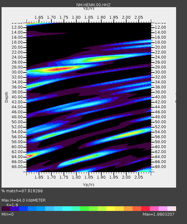
| Estimated Moho Depth: |
64.0 km |
| Estimated Crust Vp/Vs: |
1.60 |
| Assumed Crust Vp: |
6.444 km/s |
| Estimated Crust Vs: |
4.027 km/s |
| Estimated Crust Poisson's Ratio: |
0.18 |
|
| Radial Match: |
87.919266 % |
| Radial Bump: |
321 |
| Transverse Match: |
68.44141 % |
| Transverse Bump: |
330 |
| SOD ConfigId: |
3045211 |
| Insert Time: |
2018-10-27 11:23:02.070 +0000 |
| GWidth: |
2.5 |
| Max Bumps: |
400 |
| Tol: |
0.001 |
|

Signal To Noise
| Channel | StoN | STA | LTA |
| NM:HENM:00:HHZ:20181013T11:20:49.549988Z | 35.7571 | 6.646315E-6 | 1.85874E-7 |
| NM:HENM:00:HHN:20181013T11:20:49.549988Z | 11.979134 | 6.1337855E-6 | 5.120392E-7 |
| NM:HENM:00:HHE:20181013T11:20:49.549988Z | 5.8164816 | 3.3014255E-6 | 5.6759836E-7 |
| Arrivals |
| Ps | 6.2 SECOND |
| PpPs | 25 SECOND |
| PsPs/PpSs | 31 SECOND |


