You are here: Home > Network List > NM - Cooperative New Madrid Seismic Network Stations List
> Station LPAR Lepanto,AR > Earthquake Result Viewer
LPAR Lepanto,AR - Earthquake Result Viewer
| Earthquake location: |
Northwest Of Kuril Islands |
| Earthquake latitude/longitude: |
52.7/153.7 |
| Earthquake time(UTC): |
2018/10/13 (286) 11:10:19 GMT |
| Earthquake Depth: |
397 km |
| Earthquake Magnitude: |
6.7 Mi |
| Earthquake Catalog/Contributor: |
NEIC PDE/pt |
|
| Network: |
NM Cooperative New Madrid Seismic Network |
| Station: |
LPAR Lepanto,AR |
| Lat/Lon: |
35.60 N/90.30 W |
| Elevation: |
67 m |
|
| Distance: |
76.0 deg |
| Az: |
49.005 deg |
| Baz: |
325.69 deg |
| Ray Param: |
0.05015183 |
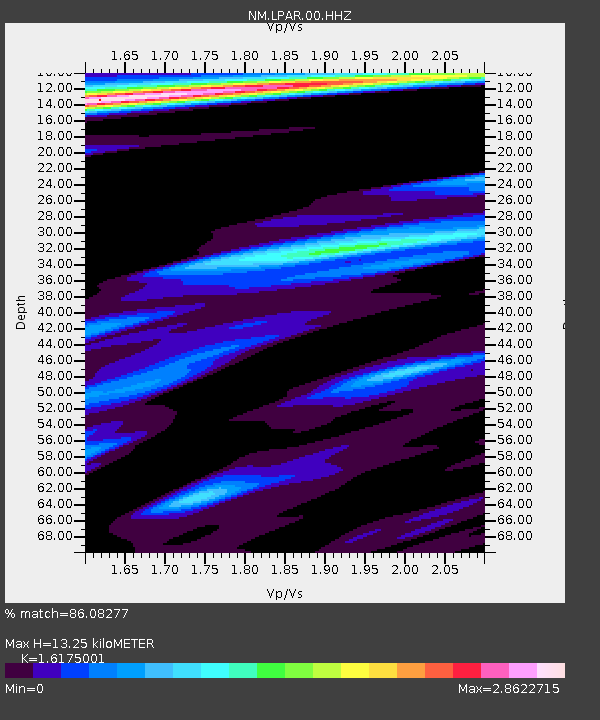
| Estimated Moho Depth: |
13.25 km |
| Estimated Crust Vp/Vs: |
1.62 |
| Assumed Crust Vp: |
6.273 km/s |
| Estimated Crust Vs: |
3.878 km/s |
| Estimated Crust Poisson's Ratio: |
0.19 |
|
| Radial Match: |
86.08277 % |
| Radial Bump: |
383 |
| Transverse Match: |
67.2848 % |
| Transverse Bump: |
400 |
| SOD ConfigId: |
3045211 |
| Insert Time: |
2018-10-27 11:23:07.113 +0000 |
| GWidth: |
2.5 |
| Max Bumps: |
400 |
| Tol: |
0.001 |
|

Signal To Noise
| Channel | StoN | STA | LTA |
| NM:LPAR:00:HHZ:20181013T11:20:52.575012Z | 53.059605 | 1.3529964E-5 | 2.5499557E-7 |
| NM:LPAR:00:HHN:20181013T11:20:52.575012Z | 7.1733456 | 6.4173882E-6 | 8.946158E-7 |
| NM:LPAR:00:HHE:20181013T11:20:52.575012Z | 4.25937 | 3.866154E-6 | 9.0768225E-7 |
| Arrivals |
| Ps | 1.3 SECOND |
| PpPs | 5.4 SECOND |
| PsPs/PpSs | 6.7 SECOND |


