You are here: Home > Network List > UU - University of Utah Regional Network Stations List
> Station FORU South Mineral Mountains, UT, USA > Earthquake Result Viewer
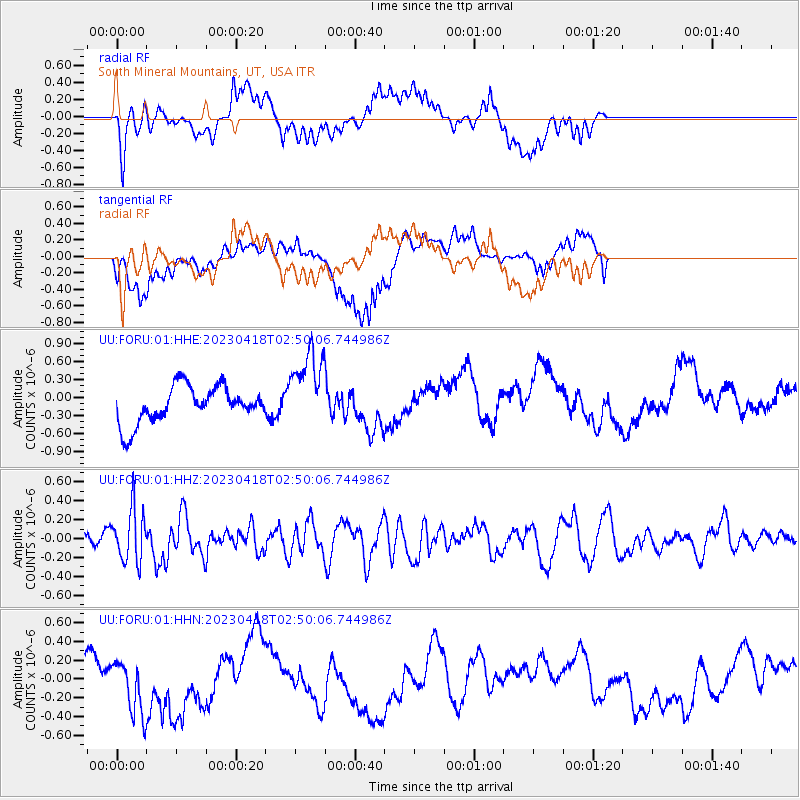
FORU South Mineral Mountains, UT, USA - Earthquake Result Viewer
*The percent match for this event was below the threshold and hence no stack was calculated.
| Earthquake location: |
Near East Coast Of Kamchatka |
| Earthquake latitude/longitude: |
54.2/159.8 |
| Earthquake time(UTC): |
2023/04/18 (108) 02:40:53 GMT |
| Earthquake Depth: |
112 km |
| Earthquake Magnitude: |
5.6 Mww |
| Earthquake Catalog/Contributor: |
NEIC PDE/us |
|
| Network: |
UU University of Utah Regional Network |
| Station: |
FORU South Mineral Mountains, UT, USA |
| Lat/Lon: |
38.46 N/112.86 W |
| Elevation: |
1840 m |
|
| Distance: |
58.5 deg |
| Az: |
66.919 deg |
| Baz: |
316.453 deg |
| Ray Param: |
$rayparam |
*The percent match for this event was below the threshold and hence was not used in the summary stack. |
|
| Radial Match: |
48.24091 % |
| Radial Bump: |
369 |
| Transverse Match: |
61.04988 % |
| Transverse Bump: |
400 |
| SOD ConfigId: |
30536071 |
| Insert Time: |
2023-05-02 03:10:23.886 +0000 |
| GWidth: |
2.5 |
| Max Bumps: |
400 |
| Tol: |
0.001 |
|
Signal To Noise
| Channel | StoN | STA | LTA |
| UU:FORU:01:HHZ:20230418T02:50:06.744986Z | 1.9493545 | 2.8176515E-7 | 1.445428E-7 |
| UU:FORU:01:HHN:20230418T02:50:06.744986Z | 2.088685 | 2.9438183E-7 | 1.4094124E-7 |
| UU:FORU:01:HHE:20230418T02:50:06.744986Z | 2.1527374 | 6.534294E-7 | 3.0353422E-7 |
| Arrivals |
| Ps | |
| PpPs | |
| PsPs/PpSs | |


