You are here: Home > Network List > TA - USArray Transportable Network (new EarthScope stations) Stations List
> Station Q25A Bedland, Calhan, CO, USA > Earthquake Result Viewer
Q25A Bedland, Calhan, CO, USA - Earthquake Result Viewer
| Earthquake location: |
Vanuatu Islands |
| Earthquake latitude/longitude: |
-13.6/167.2 |
| Earthquake time(UTC): |
2010/03/04 (063) 14:02:27 GMT |
| Earthquake Depth: |
176 km |
| Earthquake Magnitude: |
6.0 MB, 6.5 MW, 6.4 MW |
| Earthquake Catalog/Contributor: |
WHDF/NEIC |
|
| Network: |
TA USArray Transportable Network (new EarthScope stations) |
| Station: |
Q25A Bedland, Calhan, CO, USA |
| Lat/Lon: |
38.91 N/104.25 W |
| Elevation: |
2001 m |
|
| Distance: |
97.3 deg |
| Az: |
51.83 deg |
| Baz: |
258.513 deg |
| Ray Param: |
0.04011483 |
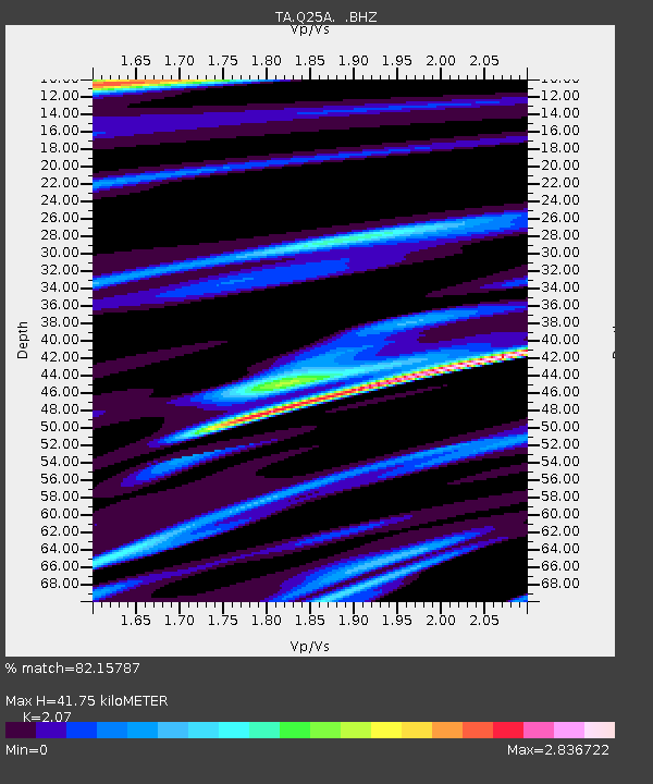
| Estimated Moho Depth: |
41.75 km |
| Estimated Crust Vp/Vs: |
2.07 |
| Assumed Crust Vp: |
6.159 km/s |
| Estimated Crust Vs: |
2.975 km/s |
| Estimated Crust Poisson's Ratio: |
0.35 |
|
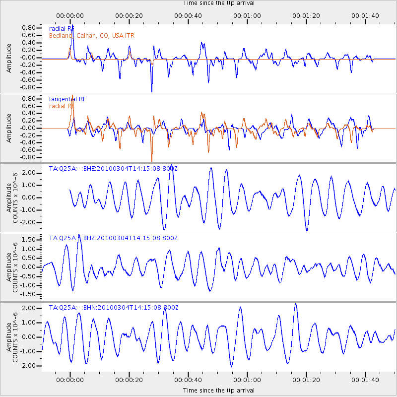
| Radial Match: |
82.15787 % |
| Radial Bump: |
353 |
| Transverse Match: |
43.484997 % |
| Transverse Bump: |
340 |
| SOD ConfigId: |
308276 |
| Insert Time: |
2010-06-22 16:18:39.534 +0000 |
| GWidth: |
2.5 |
| Max Bumps: |
400 |
| Tol: |
0.001 |
|
Signal To Noise
| Channel | StoN | STA | LTA |
| TA:Q25A: :BHZ:20100304T14:15:08.800Z | 2.3157215 | 1.0283474E-6 | 4.4407213E-7 |
| TA:Q25A: :BHN:20100304T14:15:08.800Z | 1.1283687 | 1.163646E-6 | 1.0312639E-6 |
| TA:Q25A: :BHE:20100304T14:15:08.800Z | 2.378232 | 1.7968422E-6 | 7.555369E-7 |
| Arrivals |
| Ps | 7.4 SECOND |
| PpPs | 21 SECOND |
| PsPs/PpSs | 28 SECOND |


