You are here: Home > Network List > NO - Norwegian Seismic Array Network Stations List
> Station SPB4 SPITSBERGEN ARRAY SITE B4, SVALBARD > Earthquake Result Viewer
SPB4 SPITSBERGEN ARRAY SITE B4, SVALBARD - Earthquake Result Viewer

| Earthquake location: |
Northwest Of Kuril Islands |
| Earthquake latitude/longitude: |
52.7/153.7 |
| Earthquake time(UTC): |
2018/10/13 (286) 11:10:19 GMT |
| Earthquake Depth: |
397 km |
| Earthquake Magnitude: |
6.7 Mi |
| Earthquake Catalog/Contributor: |
NEIC PDE/pt |
|
| Network: |
NO Norwegian Seismic Array Network |
| Station: |
SPB4 SPITSBERGEN ARRAY SITE B4, SVALBARD |
| Lat/Lon: |
78.18 N/16.35 E |
| Elevation: |
340 m |
|
| Distance: |
46.8 deg |
| Az: |
348.952 deg |
| Baz: |
34.446 deg |
| Ray Param: |
0.06869017 |
| Estimated Moho Depth: |
48.5 km |
| Estimated Crust Vp/Vs: |
2.09 |
| Assumed Crust Vp: |
6.545 km/s |
| Estimated Crust Vs: |
3.132 km/s |
| Estimated Crust Poisson's Ratio: |
0.35 |
|
| Radial Match: |
80.88973 % |
| Radial Bump: |
400 |
| Transverse Match: |
71.603264 % |
| Transverse Bump: |
400 |
| SOD ConfigId: |
3045211 |
| Insert Time: |
2018-10-27 11:23:29.320 +0000 |
| GWidth: |
2.5 |
| Max Bumps: |
400 |
| Tol: |
0.001 |
|
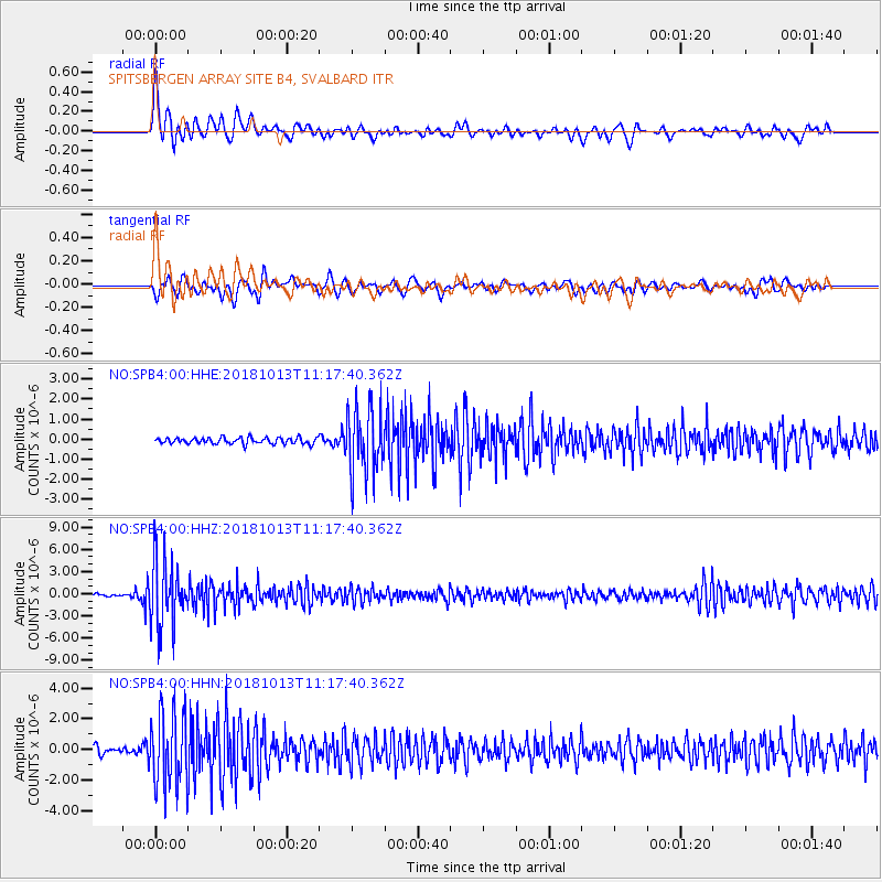
Signal To Noise
| Channel | StoN | STA | LTA |
| NO:SPB4:00:HHZ:20181013T11:17:40.362Z | 28.512535 | 4.4698236E-6 | 1.5676697E-7 |
| NO:SPB4:00:HHN:20181013T11:17:40.362Z | 13.15317 | 2.4653634E-6 | 1.8743492E-7 |
| NO:SPB4:00:HHE:20181013T11:17:40.362Z | 10.612156 | 1.6490568E-6 | 1.553932E-7 |
| Arrivals |
| Ps | 8.5 SECOND |
| PpPs | 22 SECOND |
| PsPs/PpSs | 30 SECOND |


