You are here: Home > Network List > PS - Pacific21 Stations List
> Station JAY Jayapura, Indonesia > Earthquake Result Viewer
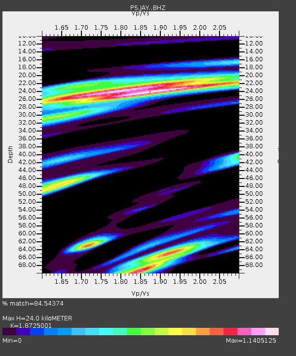
JAY Jayapura, Indonesia - Earthquake Result Viewer
| Earthquake location: |
South Of Fiji Islands |
| Earthquake latitude/longitude: |
-22.3/179.5 |
| Earthquake time(UTC): |
2023/04/18 (108) 04:31:41 GMT |
| Earthquake Depth: |
602 km |
| Earthquake Magnitude: |
6.5 Mi |
| Earthquake Catalog/Contributor: |
NEIC PDE/at |
|
| Network: |
PS Pacific21 |
| Station: |
JAY Jayapura, Indonesia |
| Lat/Lon: |
2.51 S/140.70 E |
| Elevation: |
439 m |
|
| Distance: |
42.5 deg |
| Az: |
292.039 deg |
| Baz: |
120.768 deg |
| Ray Param: |
0.07004946 |
| Estimated Moho Depth: |
24.0 km |
| Estimated Crust Vp/Vs: |
1.87 |
| Assumed Crust Vp: |
6.461 km/s |
| Estimated Crust Vs: |
3.451 km/s |
| Estimated Crust Poisson's Ratio: |
0.30 |
|
| Radial Match: |
84.54374 % |
| Radial Bump: |
400 |
| Transverse Match: |
70.75228 % |
| Transverse Bump: |
400 |
| SOD ConfigId: |
30536071 |
| Insert Time: |
2023-05-02 04:44:24.296 +0000 |
| GWidth: |
2.5 |
| Max Bumps: |
400 |
| Tol: |
0.001 |
|

Signal To Noise
| Channel | StoN | STA | LTA |
| PS:JAY: :BHZ:20230418T04:38:14.210999Z | 2.2212265 | 1.2146752E-7 | 5.468489E-8 |
| PS:JAY: :BHN:20230418T04:38:14.210999Z | 0.73479813 | 6.891725E-8 | 9.3790725E-8 |
| PS:JAY: :BHE:20230418T04:38:14.210999Z | 0.77931726 | 5.0825154E-8 | 6.521754E-8 |
| Arrivals |
| Ps | 3.4 SECOND |
| PpPs | 10 SECOND |
| PsPs/PpSs | 13 SECOND |


