You are here: Home > Network List > TA - USArray Transportable Network (new EarthScope stations) Stations List
> Station F19A Roth Fram, Molt, MT, USA > Earthquake Result Viewer
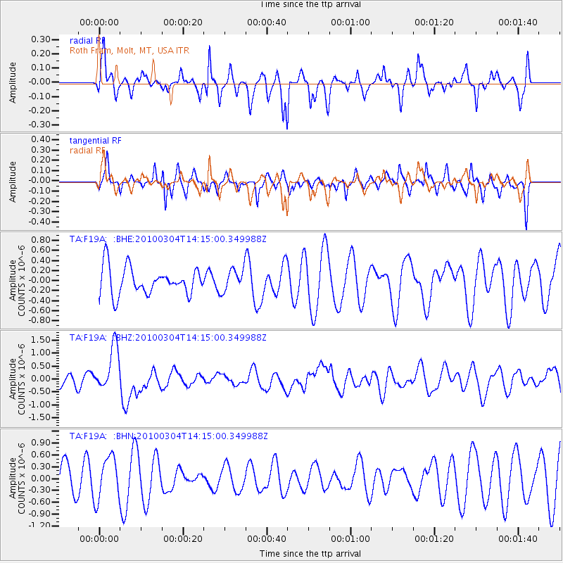
F19A Roth Fram, Molt, MT, USA - Earthquake Result Viewer
*The percent match for this event was below the threshold and hence no stack was calculated.
| Earthquake location: |
Vanuatu Islands |
| Earthquake latitude/longitude: |
-13.6/167.2 |
| Earthquake time(UTC): |
2010/03/04 (063) 14:02:27 GMT |
| Earthquake Depth: |
176 km |
| Earthquake Magnitude: |
6.0 MB, 6.5 MW, 6.4 MW |
| Earthquake Catalog/Contributor: |
WHDF/NEIC |
|
| Network: |
TA USArray Transportable Network (new EarthScope stations) |
| Station: |
F19A Roth Fram, Molt, MT, USA |
| Lat/Lon: |
45.85 N/108.94 W |
| Elevation: |
1243 m |
|
| Distance: |
95.4 deg |
| Az: |
44.26 deg |
| Baz: |
256.186 deg |
| Ray Param: |
$rayparam |
*The percent match for this event was below the threshold and hence was not used in the summary stack. |
|
| Radial Match: |
61.081417 % |
| Radial Bump: |
369 |
| Transverse Match: |
42.560905 % |
| Transverse Bump: |
395 |
| SOD ConfigId: |
308276 |
| Insert Time: |
2010-06-22 16:20:06.590 +0000 |
| GWidth: |
2.5 |
| Max Bumps: |
400 |
| Tol: |
0.001 |
|
Signal To Noise
| Channel | StoN | STA | LTA |
| TA:F19A: :BHZ:20100304T14:15:00.349988Z | 2.281465 | 8.9512275E-7 | 3.9234558E-7 |
| TA:F19A: :BHN:20100304T14:15:00.349988Z | 1.6985925 | 5.4257873E-7 | 3.194284E-7 |
| TA:F19A: :BHE:20100304T14:15:00.349988Z | 0.8412125 | 2.2777765E-7 | 2.7077303E-7 |
| Arrivals |
| Ps | |
| PpPs | |
| PsPs/PpSs | |


