You are here: Home > Network List > TA - USArray Transportable Network (new EarthScope stations) Stations List
> Station J20A Shoshoni, WY, USA > Earthquake Result Viewer
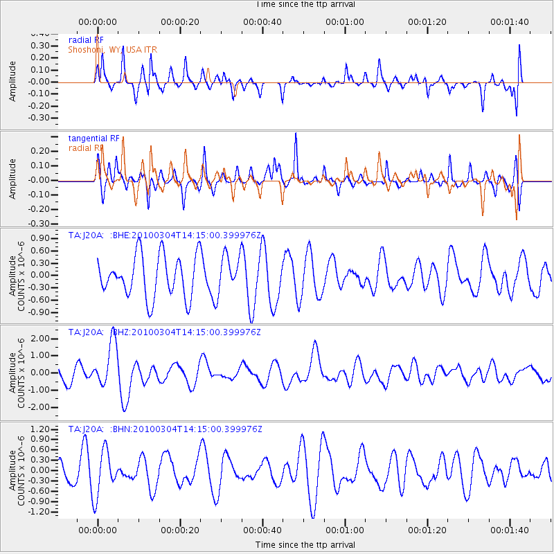
J20A Shoshoni, WY, USA - Earthquake Result Viewer
*The percent match for this event was below the threshold and hence no stack was calculated.
| Earthquake location: |
Vanuatu Islands |
| Earthquake latitude/longitude: |
-13.6/167.2 |
| Earthquake time(UTC): |
2010/03/04 (063) 14:02:27 GMT |
| Earthquake Depth: |
176 km |
| Earthquake Magnitude: |
6.0 MB, 6.5 MW, 6.4 MW |
| Earthquake Catalog/Contributor: |
WHDF/NEIC |
|
| Network: |
TA USArray Transportable Network (new EarthScope stations) |
| Station: |
J20A Shoshoni, WY, USA |
| Lat/Lon: |
43.35 N/108.08 W |
| Elevation: |
1500 m |
|
| Distance: |
95.4 deg |
| Az: |
46.846 deg |
| Baz: |
256.545 deg |
| Ray Param: |
$rayparam |
*The percent match for this event was below the threshold and hence was not used in the summary stack. |
|
| Radial Match: |
64.04598 % |
| Radial Bump: |
383 |
| Transverse Match: |
53.784702 % |
| Transverse Bump: |
387 |
| SOD ConfigId: |
308276 |
| Insert Time: |
2010-06-22 16:20:18.171 +0000 |
| GWidth: |
2.5 |
| Max Bumps: |
400 |
| Tol: |
0.001 |
|
Signal To Noise
| Channel | StoN | STA | LTA |
| TA:J20A: :BHZ:20100304T14:15:00.399976Z | 2.8045437 | 1.3622498E-6 | 4.857296E-7 |
| TA:J20A: :BHN:20100304T14:15:00.399976Z | 1.4694651 | 6.4567723E-7 | 4.3939608E-7 |
| TA:J20A: :BHE:20100304T14:15:00.399976Z | 0.8806794 | 4.44529E-7 | 5.047569E-7 |
| Arrivals |
| Ps | |
| PpPs | |
| PsPs/PpSs | |


