You are here: Home > Network List > TA - USArray Transportable Network (new EarthScope stations) Stations List
> Station A21A Bergtoll Ranch, Theony, MT, USA > Earthquake Result Viewer
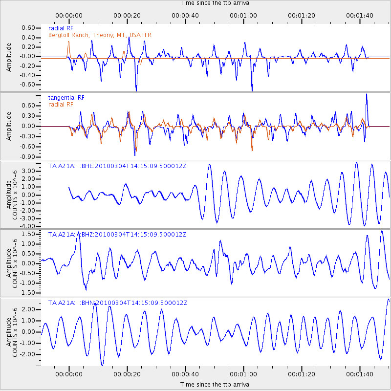
A21A Bergtoll Ranch, Theony, MT, USA - Earthquake Result Viewer
*The percent match for this event was below the threshold and hence no stack was calculated.
| Earthquake location: |
Vanuatu Islands |
| Earthquake latitude/longitude: |
-13.6/167.2 |
| Earthquake time(UTC): |
2010/03/04 (063) 14:02:27 GMT |
| Earthquake Depth: |
176 km |
| Earthquake Magnitude: |
6.0 MB, 6.5 MW, 6.4 MW |
| Earthquake Catalog/Contributor: |
WHDF/NEIC |
|
| Network: |
TA USArray Transportable Network (new EarthScope stations) |
| Station: |
A21A Bergtoll Ranch, Theony, MT, USA |
| Lat/Lon: |
48.99 N/106.93 W |
| Elevation: |
779 m |
|
| Distance: |
97.4 deg |
| Az: |
41.49 deg |
| Baz: |
257.977 deg |
| Ray Param: |
$rayparam |
*The percent match for this event was below the threshold and hence was not used in the summary stack. |
|
| Radial Match: |
32.398357 % |
| Radial Bump: |
203 |
| Transverse Match: |
57.08591 % |
| Transverse Bump: |
333 |
| SOD ConfigId: |
308276 |
| Insert Time: |
2010-06-22 16:21:26.195 +0000 |
| GWidth: |
2.5 |
| Max Bumps: |
400 |
| Tol: |
0.001 |
|
Signal To Noise
| Channel | StoN | STA | LTA |
| TA:A21A: :BHZ:20100304T14:15:09.500012Z | 2.3090847 | 7.978801E-7 | 3.4553958E-7 |
| TA:A21A: :BHN:20100304T14:15:09.500012Z | 1.0442331 | 9.008638E-7 | 8.627038E-7 |
| TA:A21A: :BHE:20100304T14:15:09.500012Z | 0.6153307 | 3.3524964E-7 | 5.4482837E-7 |
| Arrivals |
| Ps | |
| PpPs | |
| PsPs/PpSs | |


