You are here: Home > Network List > TX - Texas Seismological Network Stations List
> Station FW16 Waxahatchie > Earthquake Result Viewer
FW16 Waxahatchie - Earthquake Result Viewer
| Earthquake location: |
Northwest Of Kuril Islands |
| Earthquake latitude/longitude: |
52.7/153.7 |
| Earthquake time(UTC): |
2018/10/13 (286) 11:10:19 GMT |
| Earthquake Depth: |
397 km |
| Earthquake Magnitude: |
6.7 Mi |
| Earthquake Catalog/Contributor: |
NEIC PDE/pt |
|
| Network: |
TX Texas Seismological Network |
| Station: |
FW16 Waxahatchie |
| Lat/Lon: |
32.48 N/96.90 W |
| Elevation: |
215 m |
|
| Distance: |
75.3 deg |
| Az: |
55.473 deg |
| Baz: |
323.613 deg |
| Ray Param: |
0.05056915 |
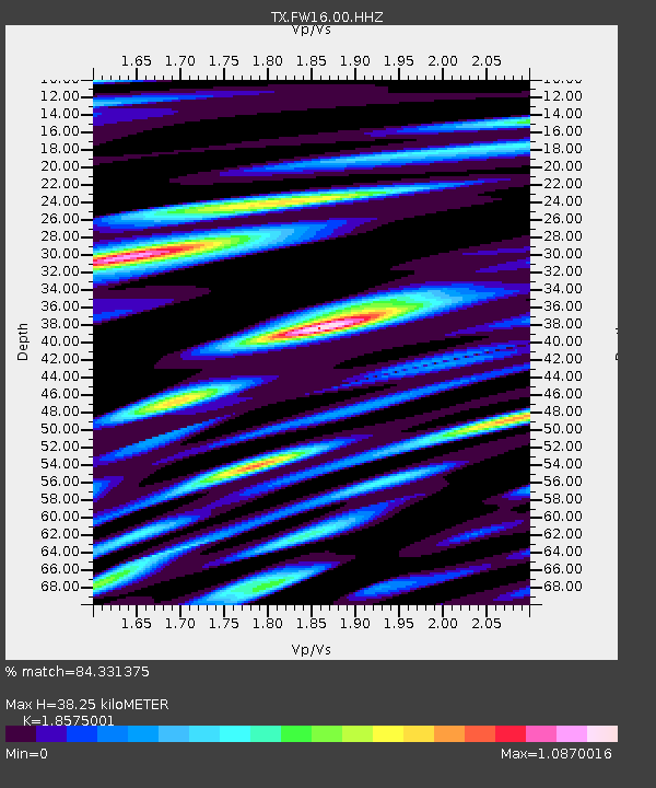
| Estimated Moho Depth: |
38.25 km |
| Estimated Crust Vp/Vs: |
1.86 |
| Assumed Crust Vp: |
6.38 km/s |
| Estimated Crust Vs: |
3.435 km/s |
| Estimated Crust Poisson's Ratio: |
0.30 |
|
| Radial Match: |
84.331375 % |
| Radial Bump: |
400 |
| Transverse Match: |
71.150215 % |
| Transverse Bump: |
400 |
| SOD ConfigId: |
3045211 |
| Insert Time: |
2018-10-27 11:24:26.226 +0000 |
| GWidth: |
2.5 |
| Max Bumps: |
400 |
| Tol: |
0.001 |
|

Signal To Noise
| Channel | StoN | STA | LTA |
| TX:FW16:00:HHZ:20181013T11:20:49.030029Z | 27.185696 | 6.372843E-6 | 2.3441899E-7 |
| TX:FW16:00:HH1:20181013T11:20:49.030029Z | 10.469238 | 2.1685014E-6 | 2.0713077E-7 |
| TX:FW16:00:HH2:20181013T11:20:49.030029Z | 7.3597536 | 1.8100244E-6 | 2.4593547E-7 |
| Arrivals |
| Ps | 5.3 SECOND |
| PpPs | 17 SECOND |
| PsPs/PpSs | 22 SECOND |


