You are here: Home > Network List > G - GEOSCOPE Stations List
> Station INU Inuyama, Japan > Earthquake Result Viewer
INU Inuyama, Japan - Earthquake Result Viewer
| Earthquake location: |
New Britain Region, P.N.G. |
| Earthquake latitude/longitude: |
-5.9/149.6 |
| Earthquake time(UTC): |
2023/04/19 (109) 09:06:03 GMT |
| Earthquake Depth: |
40 km |
| Earthquake Magnitude: |
6.3 mww |
| Earthquake Catalog/Contributor: |
NEIC PDE/us |
|
| Network: |
G GEOSCOPE |
| Station: |
INU Inuyama, Japan |
| Lat/Lon: |
35.35 N/137.03 E |
| Elevation: |
132 m |
|
| Distance: |
42.8 deg |
| Az: |
344.767 deg |
| Baz: |
161.354 deg |
| Ray Param: |
0.07289501 |
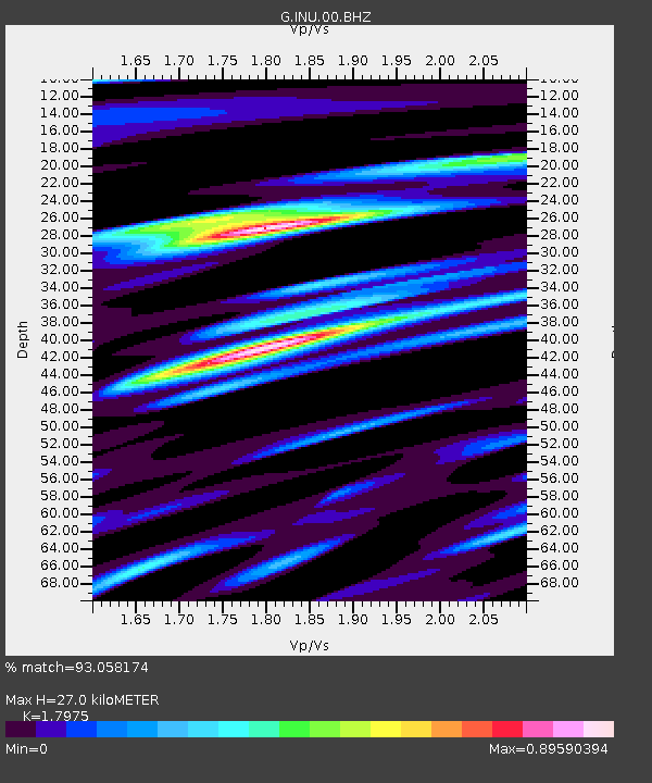
| Estimated Moho Depth: |
27.0 km |
| Estimated Crust Vp/Vs: |
1.80 |
| Assumed Crust Vp: |
6.461 km/s |
| Estimated Crust Vs: |
3.595 km/s |
| Estimated Crust Poisson's Ratio: |
0.28 |
|
| Radial Match: |
93.058174 % |
| Radial Bump: |
380 |
| Transverse Match: |
76.1418 % |
| Transverse Bump: |
400 |
| SOD ConfigId: |
30536071 |
| Insert Time: |
2023-05-03 09:19:21.951 +0000 |
| GWidth: |
2.5 |
| Max Bumps: |
400 |
| Tol: |
0.001 |
|

Signal To Noise
| Channel | StoN | STA | LTA |
| G:INU:00:BHZ:20230419T09:13:26.210993Z | 25.97026 | 4.299801E-6 | 1.6556633E-7 |
| G:INU:00:BHN:20230419T09:13:26.210993Z | 18.993893 | 2.4191836E-6 | 1.2736639E-7 |
| G:INU:00:BHE:20230419T09:13:26.210993Z | 3.5886517 | 3.0443042E-7 | 8.483142E-8 |
| Arrivals |
| Ps | 3.6 SECOND |
| PpPs | 11 SECOND |
| PsPs/PpSs | 14 SECOND |


