You are here: Home > Network List > TX - Texas Seismological Network Stations List
> Station PLPT Palo Pinto > Earthquake Result Viewer
PLPT Palo Pinto - Earthquake Result Viewer
| Earthquake location: |
Northwest Of Kuril Islands |
| Earthquake latitude/longitude: |
52.7/153.7 |
| Earthquake time(UTC): |
2018/10/13 (286) 11:10:19 GMT |
| Earthquake Depth: |
397 km |
| Earthquake Magnitude: |
6.7 Mi |
| Earthquake Catalog/Contributor: |
NEIC PDE/pt |
|
| Network: |
TX Texas Seismological Network |
| Station: |
PLPT Palo Pinto |
| Lat/Lon: |
32.81 N/98.32 W |
| Elevation: |
336 m |
|
| Distance: |
74.4 deg |
| Az: |
56.264 deg |
| Baz: |
323.058 deg |
| Ray Param: |
0.05120842 |
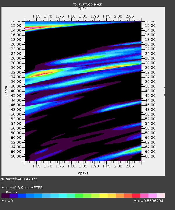
| Estimated Moho Depth: |
13.0 km |
| Estimated Crust Vp/Vs: |
1.60 |
| Assumed Crust Vp: |
6.426 km/s |
| Estimated Crust Vs: |
4.016 km/s |
| Estimated Crust Poisson's Ratio: |
0.18 |
|
| Radial Match: |
80.44875 % |
| Radial Bump: |
308 |
| Transverse Match: |
74.35042 % |
| Transverse Bump: |
391 |
| SOD ConfigId: |
3045211 |
| Insert Time: |
2018-10-27 11:24:56.041 +0000 |
| GWidth: |
2.5 |
| Max Bumps: |
400 |
| Tol: |
0.001 |
|

Signal To Noise
| Channel | StoN | STA | LTA |
| TX:PLPT:00:HHZ:20181013T11:20:43.515015Z | 56.022625 | 5.7463694E-6 | 1.025723E-7 |
| TX:PLPT:00:HH1:20181013T11:20:43.515015Z | 9.320846 | 1.2063698E-6 | 1.2942708E-7 |
| TX:PLPT:00:HH2:20181013T11:20:43.515015Z | 14.151636 | 2.167854E-6 | 1.5318751E-7 |
| Arrivals |
| Ps | 1.3 SECOND |
| PpPs | 5.1 SECOND |
| PsPs/PpSs | 6.3 SECOND |


