You are here: Home > Network List > TX - Texas Seismological Network Stations List
> Station POST Post > Earthquake Result Viewer
POST Post - Earthquake Result Viewer
| Earthquake location: |
Northwest Of Kuril Islands |
| Earthquake latitude/longitude: |
52.7/153.7 |
| Earthquake time(UTC): |
2018/10/13 (286) 11:10:19 GMT |
| Earthquake Depth: |
397 km |
| Earthquake Magnitude: |
6.7 Mi |
| Earthquake Catalog/Contributor: |
NEIC PDE/pt |
|
| Network: |
TX Texas Seismological Network |
| Station: |
POST Post |
| Lat/Lon: |
33.07 N/101.50 W |
| Elevation: |
795 m |
|
| Distance: |
72.5 deg |
| Az: |
58.32 deg |
| Baz: |
321.92 deg |
| Ray Param: |
0.05239981 |
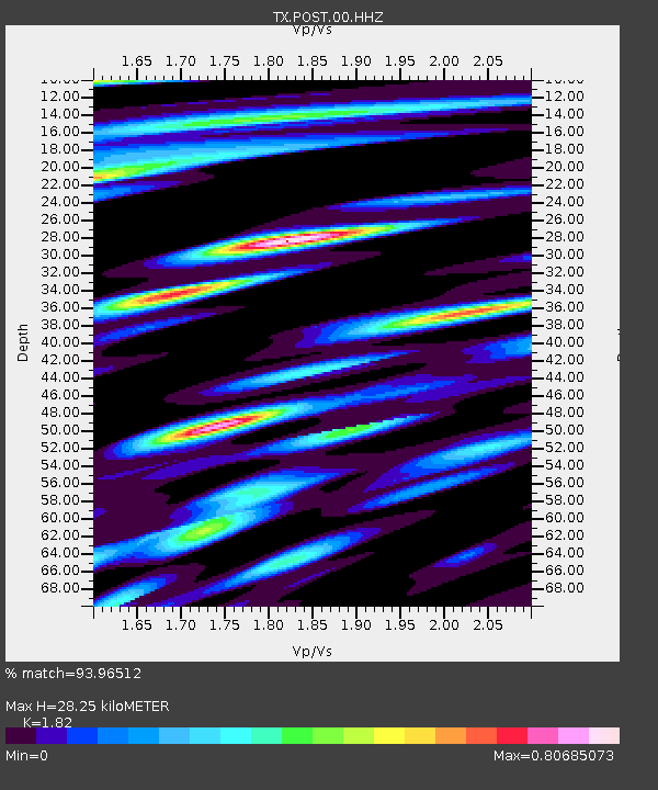
| Estimated Moho Depth: |
28.25 km |
| Estimated Crust Vp/Vs: |
1.82 |
| Assumed Crust Vp: |
6.426 km/s |
| Estimated Crust Vs: |
3.531 km/s |
| Estimated Crust Poisson's Ratio: |
0.28 |
|
| Radial Match: |
93.96512 % |
| Radial Bump: |
400 |
| Transverse Match: |
84.28857 % |
| Transverse Bump: |
400 |
| SOD ConfigId: |
3045211 |
| Insert Time: |
2018-10-27 11:24:56.982 +0000 |
| GWidth: |
2.5 |
| Max Bumps: |
400 |
| Tol: |
0.001 |
|

Signal To Noise
| Channel | StoN | STA | LTA |
| TX:POST:00:HHZ:20181013T11:20:32.994995Z | 49.664524 | 7.925827E-6 | 1.595873E-7 |
| TX:POST:00:HH1:20181013T11:20:32.994995Z | 27.900106 | 3.0764393E-6 | 1.10266214E-7 |
| TX:POST:00:HH2:20181013T11:20:32.994995Z | 7.765358 | 9.82077E-7 | 1.2646899E-7 |
| Arrivals |
| Ps | 3.7 SECOND |
| PpPs | 12 SECOND |
| PsPs/PpSs | 16 SECOND |


