You are here: Home > Network List > TX - Texas Seismological Network Stations List
> Station SGCY Sterling City > Earthquake Result Viewer
SGCY Sterling City - Earthquake Result Viewer
| Earthquake location: |
Northwest Of Kuril Islands |
| Earthquake latitude/longitude: |
52.7/153.7 |
| Earthquake time(UTC): |
2018/10/13 (286) 11:10:19 GMT |
| Earthquake Depth: |
397 km |
| Earthquake Magnitude: |
6.7 Mi |
| Earthquake Catalog/Contributor: |
NEIC PDE/pt |
|
| Network: |
TX Texas Seismological Network |
| Station: |
SGCY Sterling City |
| Lat/Lon: |
31.91 N/101.13 W |
| Elevation: |
776 m |
|
| Distance: |
73.6 deg |
| Az: |
58.796 deg |
| Baz: |
322.259 deg |
| Ray Param: |
0.05168853 |
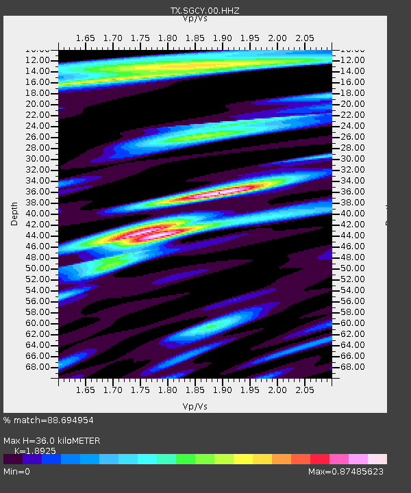
| Estimated Moho Depth: |
36.0 km |
| Estimated Crust Vp/Vs: |
1.89 |
| Assumed Crust Vp: |
6.38 km/s |
| Estimated Crust Vs: |
3.371 km/s |
| Estimated Crust Poisson's Ratio: |
0.31 |
|
| Radial Match: |
88.694954 % |
| Radial Bump: |
400 |
| Transverse Match: |
57.869823 % |
| Transverse Bump: |
400 |
| SOD ConfigId: |
3045211 |
| Insert Time: |
2018-10-27 11:25:04.401 +0000 |
| GWidth: |
2.5 |
| Max Bumps: |
400 |
| Tol: |
0.001 |
|

Signal To Noise
| Channel | StoN | STA | LTA |
| TX:SGCY:00:HHZ:20181013T11:20:39.344971Z | 46.827785 | 7.233057E-6 | 1.5446079E-7 |
| TX:SGCY:00:HH1:20181013T11:20:39.344971Z | 13.417502 | 2.1058765E-6 | 1.5694997E-7 |
| TX:SGCY:00:HH2:20181013T11:20:39.344971Z | 9.271715 | 1.5551766E-6 | 1.6773343E-7 |
| Arrivals |
| Ps | 5.2 SECOND |
| PpPs | 16 SECOND |
| PsPs/PpSs | 21 SECOND |


