You are here: Home > Network List > TX - Texas Seismological Network Stations List
> Station SN03 Snyder 3 > Earthquake Result Viewer
SN03 Snyder 3 - Earthquake Result Viewer
| Earthquake location: |
Northwest Of Kuril Islands |
| Earthquake latitude/longitude: |
52.7/153.7 |
| Earthquake time(UTC): |
2018/10/13 (286) 11:10:19 GMT |
| Earthquake Depth: |
397 km |
| Earthquake Magnitude: |
6.7 Mi |
| Earthquake Catalog/Contributor: |
NEIC PDE/pt |
|
| Network: |
TX Texas Seismological Network |
| Station: |
SN03 Snyder 3 |
| Lat/Lon: |
32.92 N/100.94 W |
| Elevation: |
744 m |
|
| Distance: |
72.9 deg |
| Az: |
58.022 deg |
| Baz: |
322.135 deg |
| Ray Param: |
0.052137822 |
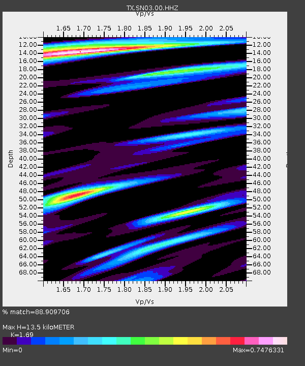
| Estimated Moho Depth: |
13.5 km |
| Estimated Crust Vp/Vs: |
1.69 |
| Assumed Crust Vp: |
6.426 km/s |
| Estimated Crust Vs: |
3.802 km/s |
| Estimated Crust Poisson's Ratio: |
0.23 |
|
| Radial Match: |
88.909706 % |
| Radial Bump: |
302 |
| Transverse Match: |
69.5991 % |
| Transverse Bump: |
400 |
| SOD ConfigId: |
3045211 |
| Insert Time: |
2018-10-27 11:25:10.682 +0000 |
| GWidth: |
2.5 |
| Max Bumps: |
400 |
| Tol: |
0.001 |
|
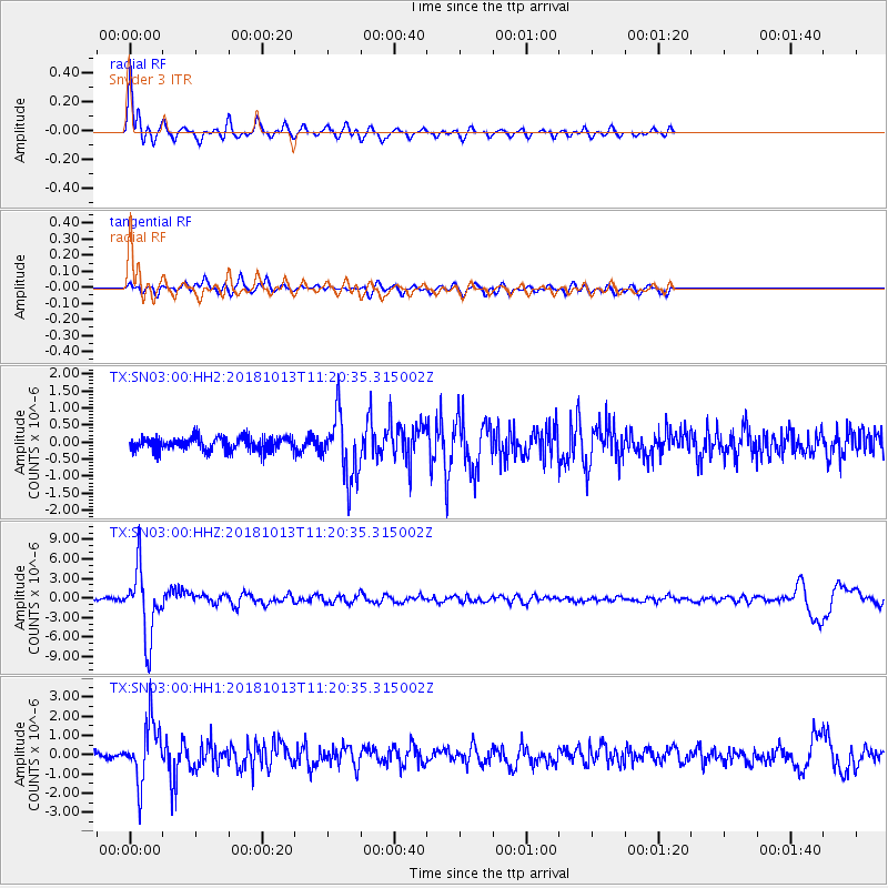
Signal To Noise
| Channel | StoN | STA | LTA |
| TX:SN03:00:HHZ:20181013T11:20:35.315002Z | 27.892048 | 5.1464544E-6 | 1.8451331E-7 |
| TX:SN03:00:HH1:20181013T11:20:35.315002Z | 8.68409 | 1.5361093E-6 | 1.7688777E-7 |
| TX:SN03:00:HH2:20181013T11:20:35.315002Z | 4.7387953 | 9.406184E-7 | 1.9849315E-7 |
| Arrivals |
| Ps | 1.5 SECOND |
| PpPs | 5.5 SECOND |
| PsPs/PpSs | 7.0 SECOND |


