You are here: Home > Network List > TX - Texas Seismological Network Stations List
> Station SN06 Snyder 6 > Earthquake Result Viewer
SN06 Snyder 6 - Earthquake Result Viewer
| Earthquake location: |
Northwest Of Kuril Islands |
| Earthquake latitude/longitude: |
52.7/153.7 |
| Earthquake time(UTC): |
2018/10/13 (286) 11:10:19 GMT |
| Earthquake Depth: |
397 km |
| Earthquake Magnitude: |
6.7 Mi |
| Earthquake Catalog/Contributor: |
NEIC PDE/pt |
|
| Network: |
TX Texas Seismological Network |
| Station: |
SN06 Snyder 6 |
| Lat/Lon: |
32.88 N/100.93 W |
| Elevation: |
769 m |
|
| Distance: |
73.0 deg |
| Az: |
58.047 deg |
| Baz: |
322.146 deg |
| Ray Param: |
0.052111123 |
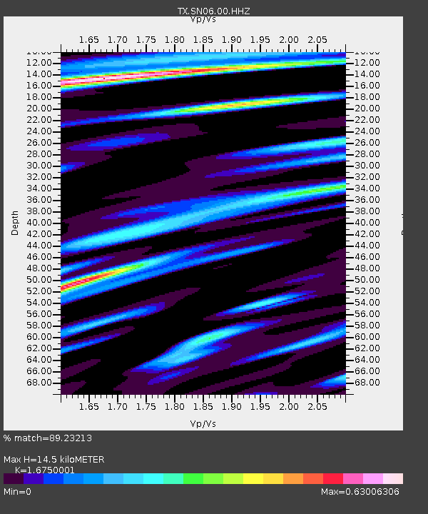
| Estimated Moho Depth: |
14.5 km |
| Estimated Crust Vp/Vs: |
1.68 |
| Assumed Crust Vp: |
6.426 km/s |
| Estimated Crust Vs: |
3.836 km/s |
| Estimated Crust Poisson's Ratio: |
0.22 |
|
| Radial Match: |
89.23213 % |
| Radial Bump: |
400 |
| Transverse Match: |
68.34229 % |
| Transverse Bump: |
400 |
| SOD ConfigId: |
3045211 |
| Insert Time: |
2018-10-27 11:25:14.046 +0000 |
| GWidth: |
2.5 |
| Max Bumps: |
400 |
| Tol: |
0.001 |
|
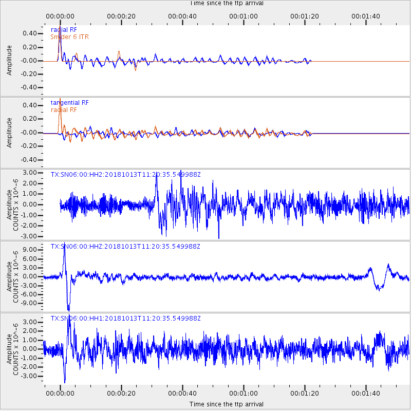
Signal To Noise
| Channel | StoN | STA | LTA |
| TX:SN06:00:HHZ:20181013T11:20:35.549988Z | 18.438442 | 5.195024E-6 | 2.817496E-7 |
| TX:SN06:00:HH1:20181013T11:20:35.549988Z | 3.0295718 | 1.7292809E-6 | 5.7080047E-7 |
| TX:SN06:00:HH2:20181013T11:20:35.549988Z | 2.8705168 | 1.3420965E-6 | 4.6754528E-7 |
| Arrivals |
| Ps | 1.6 SECOND |
| PpPs | 5.8 SECOND |
| PsPs/PpSs | 7.4 SECOND |


