You are here: Home > Network List > TX - Texas Seismological Network Stations List
> Station SNAG San Augustine > Earthquake Result Viewer
SNAG San Augustine - Earthquake Result Viewer
| Earthquake location: |
Northwest Of Kuril Islands |
| Earthquake latitude/longitude: |
52.7/153.7 |
| Earthquake time(UTC): |
2018/10/13 (286) 11:10:19 GMT |
| Earthquake Depth: |
397 km |
| Earthquake Magnitude: |
6.7 Mi |
| Earthquake Catalog/Contributor: |
NEIC PDE/pt |
|
| Network: |
TX Texas Seismological Network |
| Station: |
SNAG San Augustine |
| Lat/Lon: |
31.52 N/94.18 W |
| Elevation: |
84 m |
|
| Distance: |
77.5 deg |
| Az: |
54.125 deg |
| Baz: |
324.73 deg |
| Ray Param: |
0.04916245 |
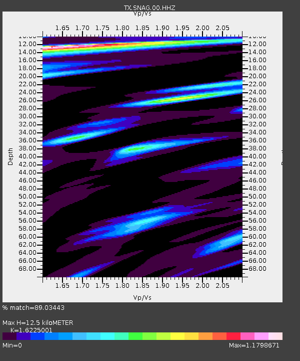
| Estimated Moho Depth: |
12.5 km |
| Estimated Crust Vp/Vs: |
1.62 |
| Assumed Crust Vp: |
5.738 km/s |
| Estimated Crust Vs: |
3.537 km/s |
| Estimated Crust Poisson's Ratio: |
0.19 |
|
| Radial Match: |
89.03443 % |
| Radial Bump: |
400 |
| Transverse Match: |
73.08136 % |
| Transverse Bump: |
384 |
| SOD ConfigId: |
3045211 |
| Insert Time: |
2018-10-27 11:25:17.629 +0000 |
| GWidth: |
2.5 |
| Max Bumps: |
400 |
| Tol: |
0.001 |
|
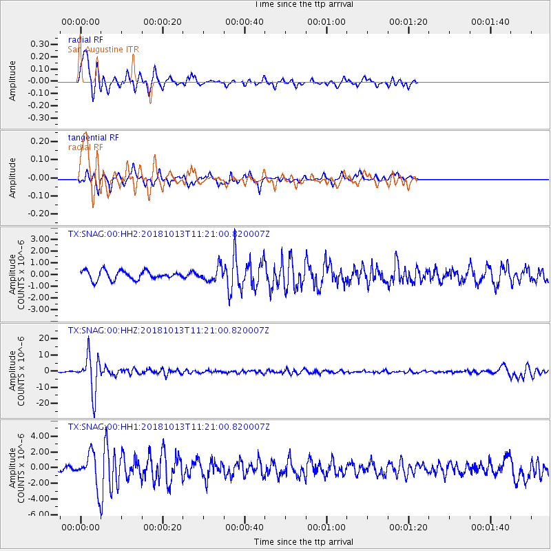
Signal To Noise
| Channel | StoN | STA | LTA |
| TX:SNAG:00:HHZ:20181013T11:21:00.820007Z | 46.091698 | 1.1733384E-5 | 2.545661E-7 |
| TX:SNAG:00:HH1:20181013T11:21:00.820007Z | 6.4280257 | 2.1585633E-6 | 3.3580503E-7 |
| TX:SNAG:00:HH2:20181013T11:21:00.820007Z | 1.6399851 | 6.1759874E-7 | 3.7658802E-7 |
| Arrivals |
| Ps | 1.4 SECOND |
| PpPs | 5.6 SECOND |
| PsPs/PpSs | 7.0 SECOND |


