You are here: Home > Network List > TX - Texas Seismological Network Stations List
> Station WTFS Witchita Falls > Earthquake Result Viewer
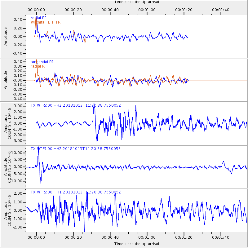
WTFS Witchita Falls - Earthquake Result Viewer
*The percent match for this event was below the threshold and hence no stack was calculated.
| Earthquake location: |
Northwest Of Kuril Islands |
| Earthquake latitude/longitude: |
52.7/153.7 |
| Earthquake time(UTC): |
2018/10/13 (286) 11:10:19 GMT |
| Earthquake Depth: |
397 km |
| Earthquake Magnitude: |
6.7 Mi |
| Earthquake Catalog/Contributor: |
NEIC PDE/pt |
|
| Network: |
TX Texas Seismological Network |
| Station: |
WTFS Witchita Falls |
| Lat/Lon: |
33.77 N/98.46 W |
| Elevation: |
277 m |
|
| Distance: |
73.5 deg |
| Az: |
55.771 deg |
| Baz: |
322.841 deg |
| Ray Param: |
$rayparam |
*The percent match for this event was below the threshold and hence was not used in the summary stack. |
|
| Radial Match: |
78.82178 % |
| Radial Bump: |
278 |
| Transverse Match: |
66.73736 % |
| Transverse Bump: |
397 |
| SOD ConfigId: |
3045211 |
| Insert Time: |
2018-10-27 11:25:20.965 +0000 |
| GWidth: |
2.5 |
| Max Bumps: |
400 |
| Tol: |
0.001 |
|
Signal To Noise
| Channel | StoN | STA | LTA |
| TX:WTFS:00:HHZ:20181013T11:20:38.755005Z | 40.930706 | 5.3739823E-6 | 1.3129463E-7 |
| TX:WTFS:00:HH1:20181013T11:20:38.755005Z | 3.9862888 | 5.7803015E-7 | 1.4500458E-7 |
| TX:WTFS:00:HH2:20181013T11:20:38.755005Z | 6.8125525 | 1.6573188E-6 | 2.432743E-7 |
| Arrivals |
| Ps | |
| PpPs | |
| PsPs/PpSs | |


