You are here: Home > Network List > US - United States National Seismic Network Stations List
> Station BLA Blacksburg, Virginia, USA > Earthquake Result Viewer
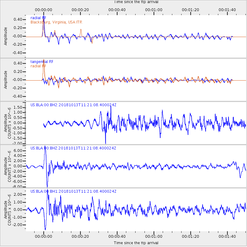
BLA Blacksburg, Virginia, USA - Earthquake Result Viewer
*The percent match for this event was below the threshold and hence no stack was calculated.
| Earthquake location: |
Northwest Of Kuril Islands |
| Earthquake latitude/longitude: |
52.7/153.7 |
| Earthquake time(UTC): |
2018/10/13 (286) 11:10:19 GMT |
| Earthquake Depth: |
397 km |
| Earthquake Magnitude: |
6.7 Mi |
| Earthquake Catalog/Contributor: |
NEIC PDE/pt |
|
| Network: |
US United States National Seismic Network |
| Station: |
BLA Blacksburg, Virginia, USA |
| Lat/Lon: |
37.21 N/80.42 W |
| Elevation: |
634 m |
|
| Distance: |
78.9 deg |
| Az: |
41.227 deg |
| Baz: |
329.842 deg |
| Ray Param: |
$rayparam |
*The percent match for this event was below the threshold and hence was not used in the summary stack. |
|
| Radial Match: |
79.54284 % |
| Radial Bump: |
312 |
| Transverse Match: |
72.20672 % |
| Transverse Bump: |
357 |
| SOD ConfigId: |
3045211 |
| Insert Time: |
2018-10-27 11:25:37.554 +0000 |
| GWidth: |
2.5 |
| Max Bumps: |
400 |
| Tol: |
0.001 |
|
Signal To Noise
| Channel | StoN | STA | LTA |
| US:BLA:00:BHZ:20181013T11:21:08.400024Z | 12.775695 | 3.8536587E-6 | 3.0163983E-7 |
| US:BLA:00:BH1:20181013T11:21:08.400024Z | 11.669407 | 1.359302E-6 | 1.1648425E-7 |
| US:BLA:00:BH2:20181013T11:21:08.400024Z | 4.552766 | 6.81606E-7 | 1.497125E-7 |
| Arrivals |
| Ps | |
| PpPs | |
| PsPs/PpSs | |


