You are here: Home > Network List > US - United States National Seismic Network Stations List
> Station DGMT Dagmar, Montana, USA > Earthquake Result Viewer
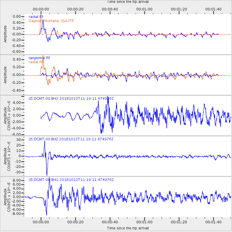
DGMT Dagmar, Montana, USA - Earthquake Result Viewer
*The percent match for this event was below the threshold and hence no stack was calculated.
| Earthquake location: |
Northwest Of Kuril Islands |
| Earthquake latitude/longitude: |
52.7/153.7 |
| Earthquake time(UTC): |
2018/10/13 (286) 11:10:19 GMT |
| Earthquake Depth: |
397 km |
| Earthquake Magnitude: |
6.7 Mi |
| Earthquake Catalog/Contributor: |
NEIC PDE/pt |
|
| Network: |
US United States National Seismic Network |
| Station: |
DGMT Dagmar, Montana, USA |
| Lat/Lon: |
48.47 N/104.20 W |
| Elevation: |
0.0 m |
|
| Distance: |
59.5 deg |
| Az: |
49.019 deg |
| Baz: |
316.341 deg |
| Ray Param: |
$rayparam |
*The percent match for this event was below the threshold and hence was not used in the summary stack. |
|
| Radial Match: |
89.424995 % |
| Radial Bump: |
400 |
| Transverse Match: |
82.637505 % |
| Transverse Bump: |
400 |
| SOD ConfigId: |
3045211 |
| Insert Time: |
2018-10-27 11:25:50.830 +0000 |
| GWidth: |
2.5 |
| Max Bumps: |
400 |
| Tol: |
0.001 |
|
Signal To Noise
| Channel | StoN | STA | LTA |
| US:DGMT:00:BHZ:20181013T11:19:11.474976Z | 39.066303 | 1.3256911E-5 | 3.393439E-7 |
| US:DGMT:00:BH1:20181013T11:19:11.474976Z | 12.323061 | 3.4151217E-6 | 2.7713259E-7 |
| US:DGMT:00:BH2:20181013T11:19:11.474976Z | 2.872837 | 2.0947089E-6 | 7.29143E-7 |
| Arrivals |
| Ps | |
| PpPs | |
| PsPs/PpSs | |


