You are here: Home > Network List > US - United States National Seismic Network Stations List
> Station LONY Lake Ozonia, New York, USA > Earthquake Result Viewer
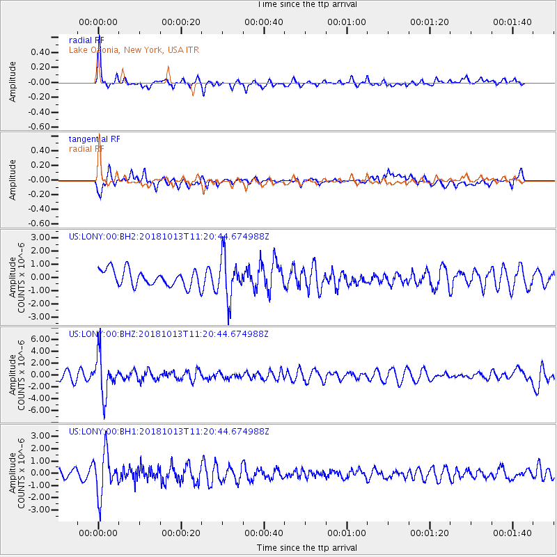
LONY Lake Ozonia, New York, USA - Earthquake Result Viewer
*The percent match for this event was below the threshold and hence no stack was calculated.
| Earthquake location: |
Northwest Of Kuril Islands |
| Earthquake latitude/longitude: |
52.7/153.7 |
| Earthquake time(UTC): |
2018/10/13 (286) 11:10:19 GMT |
| Earthquake Depth: |
397 km |
| Earthquake Magnitude: |
6.7 Mi |
| Earthquake Catalog/Contributor: |
NEIC PDE/pt |
|
| Network: |
US United States National Seismic Network |
| Station: |
LONY Lake Ozonia, New York, USA |
| Lat/Lon: |
44.62 N/74.58 W |
| Elevation: |
440 m |
|
| Distance: |
74.6 deg |
| Az: |
33.557 deg |
| Baz: |
331.896 deg |
| Ray Param: |
$rayparam |
*The percent match for this event was below the threshold and hence was not used in the summary stack. |
|
| Radial Match: |
67.35662 % |
| Radial Bump: |
390 |
| Transverse Match: |
61.94602 % |
| Transverse Bump: |
400 |
| SOD ConfigId: |
3045211 |
| Insert Time: |
2018-10-27 11:26:23.607 +0000 |
| GWidth: |
2.5 |
| Max Bumps: |
400 |
| Tol: |
0.001 |
|
Signal To Noise
| Channel | StoN | STA | LTA |
| US:LONY:00:BHZ:20181013T11:20:44.674988Z | 5.40618 | 3.3717542E-6 | 6.236852E-7 |
| US:LONY:00:BH1:20181013T11:20:44.674988Z | 3.721159 | 1.7548489E-6 | 4.7158665E-7 |
| US:LONY:00:BH2:20181013T11:20:44.674988Z | 2.6200988 | 1.6043839E-6 | 6.1233715E-7 |
| Arrivals |
| Ps | |
| PpPs | |
| PsPs/PpSs | |


