You are here: Home > Network List > US - United States National Seismic Network Stations List
> Station MNTX Cornudas Mountains, Texas, USA > Earthquake Result Viewer
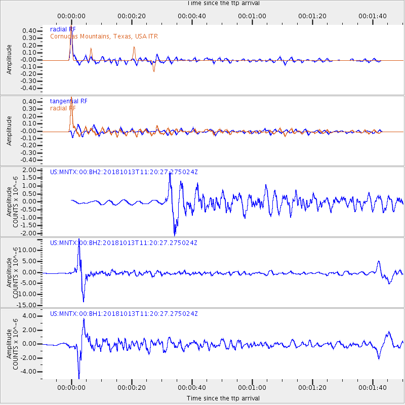
MNTX Cornudas Mountains, Texas, USA - Earthquake Result Viewer

| Earthquake location: |
Northwest Of Kuril Islands |
| Earthquake latitude/longitude: |
52.7/153.7 |
| Earthquake time(UTC): |
2018/10/13 (286) 11:10:19 GMT |
| Earthquake Depth: |
397 km |
| Earthquake Magnitude: |
6.7 Mi |
| Earthquake Catalog/Contributor: |
NEIC PDE/pt |
|
| Network: |
US United States National Seismic Network |
| Station: |
MNTX Cornudas Mountains, Texas, USA |
| Lat/Lon: |
31.70 N/105.38 W |
| Elevation: |
404 m |
|
| Distance: |
71.6 deg |
| Az: |
61.912 deg |
| Baz: |
320.958 deg |
| Ray Param: |
0.05303869 |
| Estimated Moho Depth: |
12.0 km |
| Estimated Crust Vp/Vs: |
1.61 |
| Assumed Crust Vp: |
6.361 km/s |
| Estimated Crust Vs: |
3.945 km/s |
| Estimated Crust Poisson's Ratio: |
0.19 |
|
| Radial Match: |
93.93469 % |
| Radial Bump: |
264 |
| Transverse Match: |
84.35677 % |
| Transverse Bump: |
385 |
| SOD ConfigId: |
3045211 |
| Insert Time: |
2018-10-27 11:26:29.469 +0000 |
| GWidth: |
2.5 |
| Max Bumps: |
400 |
| Tol: |
0.001 |
|
Signal To Noise
| Channel | StoN | STA | LTA |
| US:MNTX:00:BHZ:20181013T11:20:27.275024Z | 74.199585 | 6.0649722E-6 | 8.173863E-8 |
| US:MNTX:00:BH1:20181013T11:20:27.275024Z | 25.08834 | 1.8595159E-6 | 7.4118724E-8 |
| US:MNTX:00:BH2:20181013T11:20:27.275024Z | 10.061863 | 9.182582E-7 | 9.126125E-8 |
| Arrivals |
| Ps | 1.2 SECOND |
| PpPs | 4.8 SECOND |
| PsPs/PpSs | 5.9 SECOND |


