You are here: Home > Network List > US - United States National Seismic Network Stations List
> Station MSO Missoula, Montana, USA > Earthquake Result Viewer
MSO Missoula, Montana, USA - Earthquake Result Viewer
*The percent match for this event was below the threshold and hence no stack was calculated.
| Earthquake location: |
Off Coast Of Central America |
| Earthquake latitude/longitude: |
2.7/-84.4 |
| Earthquake time(UTC): |
2023/04/20 (110) 10:55:32 GMT |
| Earthquake Depth: |
10 km |
| Earthquake Magnitude: |
5.5 mww |
| Earthquake Catalog/Contributor: |
NEIC PDE/us |
|
| Network: |
US United States National Seismic Network |
| Station: |
MSO Missoula, Montana, USA |
| Lat/Lon: |
46.83 N/113.94 W |
| Elevation: |
1264 m |
|
| Distance: |
50.9 deg |
| Az: |
334.104 deg |
| Baz: |
140.552 deg |
| Ray Param: |
$rayparam |
*The percent match for this event was below the threshold and hence was not used in the summary stack. |
|
| Radial Match: |
58.33803 % |
| Radial Bump: |
340 |
| Transverse Match: |
60.218204 % |
| Transverse Bump: |
400 |
| SOD ConfigId: |
30536071 |
| Insert Time: |
2023-05-04 11:22:32.261 +0000 |
| GWidth: |
2.5 |
| Max Bumps: |
400 |
| Tol: |
0.001 |
|
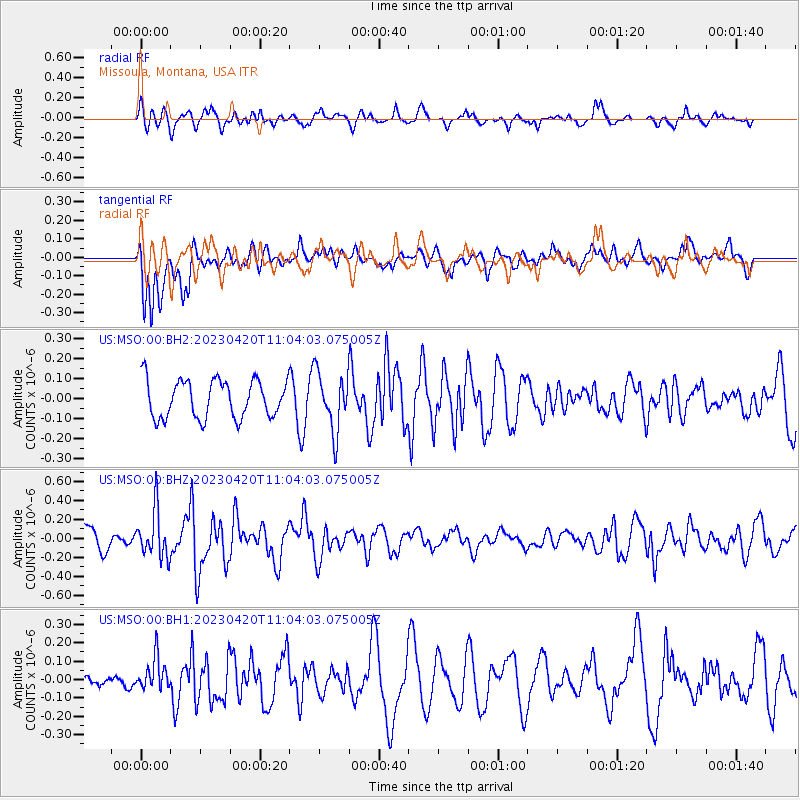
Signal To Noise
| Channel | StoN | STA | LTA |
| US:MSO:00:BHZ:20230420T11:04:03.075005Z | 1.7412256 | 2.4761127E-7 | 1.4220517E-7 |
| US:MSO:00:BH1:20230420T11:04:03.075005Z | 1.247994 | 8.769755E-8 | 7.0270815E-8 |
| US:MSO:00:BH2:20230420T11:04:03.075005Z | 1.5553073 | 1.4629542E-7 | 9.4062074E-8 |
| Arrivals |
| Ps | |
| PpPs | |
| PsPs/PpSs | |


