You are here: Home > Network List > AU - Australian Seismological Centre Stations List
> Station KMBL Kambalda, WA > Earthquake Result Viewer
KMBL Kambalda, WA - Earthquake Result Viewer
| Earthquake location: |
Northern Molucca Sea |
| Earthquake latitude/longitude: |
2.8/127.1 |
| Earthquake time(UTC): |
2023/04/21 (111) 10:21:14 GMT |
| Earthquake Depth: |
33 km |
| Earthquake Magnitude: |
5.9 mww |
| Earthquake Catalog/Contributor: |
NEIC PDE/us |
|
| Network: |
AU Australian Seismological Centre |
| Station: |
KMBL Kambalda, WA |
| Lat/Lon: |
31.37 S/121.88 E |
| Elevation: |
370 m |
|
| Distance: |
34.4 deg |
| Az: |
187.891 deg |
| Baz: |
9.225 deg |
| Ray Param: |
0.07773093 |
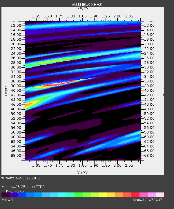
| Estimated Moho Depth: |
36.25 km |
| Estimated Crust Vp/Vs: |
1.76 |
| Assumed Crust Vp: |
6.459 km/s |
| Estimated Crust Vs: |
3.675 km/s |
| Estimated Crust Poisson's Ratio: |
0.26 |
|
| Radial Match: |
90.825386 % |
| Radial Bump: |
387 |
| Transverse Match: |
65.65864 % |
| Transverse Bump: |
400 |
| SOD ConfigId: |
30536071 |
| Insert Time: |
2023-05-05 10:24:42.511 +0000 |
| GWidth: |
2.5 |
| Max Bumps: |
400 |
| Tol: |
0.001 |
|

Signal To Noise
| Channel | StoN | STA | LTA |
| AU:KMBL:00:HHZ:20230421T10:27:28.189995Z | 5.4759817 | 7.6110723E-7 | 1.3899009E-7 |
| AU:KMBL:00:HHN:20230421T10:27:28.189995Z | 4.4134426 | 4.891737E-7 | 1.1083722E-7 |
| AU:KMBL:00:HHE:20230421T10:27:28.189995Z | 2.0162542 | 1.69234E-7 | 8.393486E-8 |
| Arrivals |
| Ps | 4.6 SECOND |
| PpPs | 14 SECOND |
| PsPs/PpSs | 19 SECOND |


