You are here: Home > Network List > UU - University of Utah Regional Network Stations List
> Station HVU Hansel Valley, UT, USA > Earthquake Result Viewer
HVU Hansel Valley, UT, USA - Earthquake Result Viewer
| Earthquake location: |
Northwest Of Kuril Islands |
| Earthquake latitude/longitude: |
52.7/153.7 |
| Earthquake time(UTC): |
2018/10/13 (286) 11:10:19 GMT |
| Earthquake Depth: |
397 km |
| Earthquake Magnitude: |
6.7 Mi |
| Earthquake Catalog/Contributor: |
NEIC PDE/pt |
|
| Network: |
UU University of Utah Regional Network |
| Station: |
HVU Hansel Valley, UT, USA |
| Lat/Lon: |
41.78 N/112.78 W |
| Elevation: |
1609 m |
|
| Distance: |
60.1 deg |
| Az: |
59.443 deg |
| Baz: |
315.517 deg |
| Ray Param: |
0.06033649 |
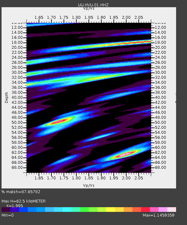
| Estimated Moho Depth: |
62.5 km |
| Estimated Crust Vp/Vs: |
2.00 |
| Assumed Crust Vp: |
6.276 km/s |
| Estimated Crust Vs: |
3.146 km/s |
| Estimated Crust Poisson's Ratio: |
0.33 |
|
| Radial Match: |
87.65782 % |
| Radial Bump: |
400 |
| Transverse Match: |
78.902885 % |
| Transverse Bump: |
400 |
| SOD ConfigId: |
3045211 |
| Insert Time: |
2018-10-27 11:27:38.162 +0000 |
| GWidth: |
2.5 |
| Max Bumps: |
400 |
| Tol: |
0.001 |
|

Signal To Noise
| Channel | StoN | STA | LTA |
| UU:HVU:01:HHZ:20181013T11:19:15.297974Z | 59.694923 | 1.9079691E-7 | 3.1962E-9 |
| UU:HVU:01:HHN:20181013T11:19:15.297974Z | 33.577015 | 7.976854E-8 | 2.3756888E-9 |
| UU:HVU:01:HHE:20181013T11:19:15.297974Z | 16.23727 | 5.4340248E-8 | 3.3466367E-9 |
| Arrivals |
| Ps | 10 SECOND |
| PpPs | 29 SECOND |
| PsPs/PpSs | 39 SECOND |


