You are here: Home > Network List > UU - University of Utah Regional Network Stations List
> Station LCMT Little Creek Mountain, UT, USA > Earthquake Result Viewer
LCMT Little Creek Mountain, UT, USA - Earthquake Result Viewer
| Earthquake location: |
Northwest Of Kuril Islands |
| Earthquake latitude/longitude: |
52.7/153.7 |
| Earthquake time(UTC): |
2018/10/13 (286) 11:10:19 GMT |
| Earthquake Depth: |
397 km |
| Earthquake Magnitude: |
6.7 Mi |
| Earthquake Catalog/Contributor: |
NEIC PDE/pt |
|
| Network: |
UU University of Utah Regional Network |
| Station: |
LCMT Little Creek Mountain, UT, USA |
| Lat/Lon: |
37.01 N/113.24 W |
| Elevation: |
1411 m |
|
| Distance: |
63.3 deg |
| Az: |
63.475 deg |
| Baz: |
317.134 deg |
| Ray Param: |
0.058318127 |
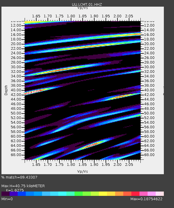
| Estimated Moho Depth: |
40.75 km |
| Estimated Crust Vp/Vs: |
1.63 |
| Assumed Crust Vp: |
6.194 km/s |
| Estimated Crust Vs: |
3.806 km/s |
| Estimated Crust Poisson's Ratio: |
0.20 |
|
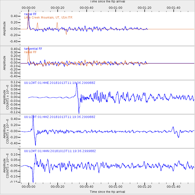
| Radial Match: |
89.43307 % |
| Radial Bump: |
400 |
| Transverse Match: |
73.99911 % |
| Transverse Bump: |
400 |
| SOD ConfigId: |
3045211 |
| Insert Time: |
2018-10-27 11:27:45.232 +0000 |
| GWidth: |
2.5 |
| Max Bumps: |
400 |
| Tol: |
0.001 |
|
Signal To Noise
| Channel | StoN | STA | LTA |
| UU:LCMT:01:HHZ:20181013T11:19:36.299988Z | 53.250698 | 1.9381027E-7 | 3.6395817E-9 |
| UU:LCMT:01:HHN:20181013T11:19:36.299988Z | 23.76556 | 5.157543E-8 | 2.1701754E-9 |
| UU:LCMT:01:HHE:20181013T11:19:36.299988Z | 18.975378 | 4.849837E-8 | 2.555858E-9 |
| Arrivals |
| Ps | 4.3 SECOND |
| PpPs | 17 SECOND |
| PsPs/PpSs | 21 SECOND |


