You are here: Home > Network List > UU - University of Utah Regional Network Stations List
> Station MPU Maple Canyon, UT, USA > Earthquake Result Viewer
MPU Maple Canyon, UT, USA - Earthquake Result Viewer
| Earthquake location: |
Northwest Of Kuril Islands |
| Earthquake latitude/longitude: |
52.7/153.7 |
| Earthquake time(UTC): |
2018/10/13 (286) 11:10:19 GMT |
| Earthquake Depth: |
397 km |
| Earthquake Magnitude: |
6.7 Mi |
| Earthquake Catalog/Contributor: |
NEIC PDE/pt |
|
| Network: |
UU University of Utah Regional Network |
| Station: |
MPU Maple Canyon, UT, USA |
| Lat/Lon: |
40.02 N/111.63 W |
| Elevation: |
1909 m |
|
| Distance: |
62.0 deg |
| Az: |
60.128 deg |
| Baz: |
316.594 deg |
| Ray Param: |
0.059153292 |
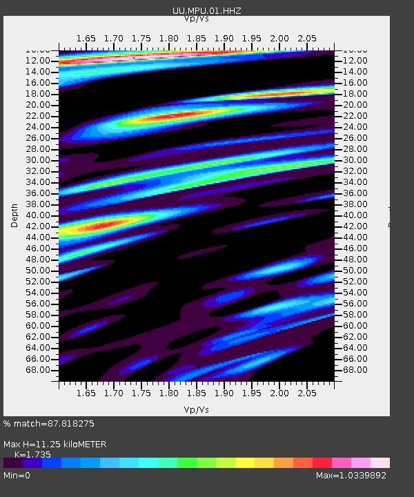
| Estimated Moho Depth: |
11.25 km |
| Estimated Crust Vp/Vs: |
1.74 |
| Assumed Crust Vp: |
6.155 km/s |
| Estimated Crust Vs: |
3.547 km/s |
| Estimated Crust Poisson's Ratio: |
0.25 |
|
| Radial Match: |
87.818275 % |
| Radial Bump: |
400 |
| Transverse Match: |
78.35932 % |
| Transverse Bump: |
400 |
| SOD ConfigId: |
3045211 |
| Insert Time: |
2018-10-27 11:27:48.736 +0000 |
| GWidth: |
2.5 |
| Max Bumps: |
400 |
| Tol: |
0.001 |
|

Signal To Noise
| Channel | StoN | STA | LTA |
| UU:MPU:01:HHZ:20181013T11:19:27.679993Z | 76.43401 | 2.51551E-7 | 3.2910872E-9 |
| UU:MPU:01:HHN:20181013T11:19:27.679993Z | 30.865223 | 7.652137E-8 | 2.47921E-9 |
| UU:MPU:01:HHE:20181013T11:19:27.679993Z | 16.530895 | 6.0476154E-8 | 3.6583712E-9 |
| Arrivals |
| Ps | 1.4 SECOND |
| PpPs | 4.8 SECOND |
| PsPs/PpSs | 6.2 SECOND |


