You are here: Home > Network List > TA - USArray Transportable Network (new EarthScope stations) Stations List
> Station X18A Snowflake, AZ, USA > Earthquake Result Viewer
X18A Snowflake, AZ, USA - Earthquake Result Viewer
| Earthquake location: |
Northern Chile |
| Earthquake latitude/longitude: |
-22.2/-68.3 |
| Earthquake time(UTC): |
2010/03/04 (063) 22:39:26 GMT |
| Earthquake Depth: |
114 km |
| Earthquake Magnitude: |
6.3 MB, 6.4 MW, 6.3 MW |
| Earthquake Catalog/Contributor: |
WHDF/NEIC |
|
| Network: |
TA USArray Transportable Network (new EarthScope stations) |
| Station: |
X18A Snowflake, AZ, USA |
| Lat/Lon: |
34.53 N/109.95 W |
| Elevation: |
1751 m |
|
| Distance: |
68.9 deg |
| Az: |
324.006 deg |
| Baz: |
138.732 deg |
| Ray Param: |
0.055692066 |
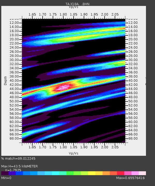
| Estimated Moho Depth: |
43.5 km |
| Estimated Crust Vp/Vs: |
1.79 |
| Assumed Crust Vp: |
6.496 km/s |
| Estimated Crust Vs: |
3.624 km/s |
| Estimated Crust Poisson's Ratio: |
0.27 |
|
| Radial Match: |
89.012245 % |
| Radial Bump: |
372 |
| Transverse Match: |
70.156364 % |
| Transverse Bump: |
400 |
| SOD ConfigId: |
308276 |
| Insert Time: |
2010-06-22 16:42:59.860 +0000 |
| GWidth: |
2.5 |
| Max Bumps: |
400 |
| Tol: |
0.001 |
|

Signal To Noise
| Channel | StoN | STA | LTA |
| TA:X18A: :BHZ:20100304T22:49:48.350007Z | 17.68659 | 3.670574E-6 | 2.075343E-7 |
| TA:X18A: :BHN:20100304T22:49:48.350007Z | 6.1489205 | 1.3012568E-6 | 2.1162363E-7 |
| TA:X18A: :BHE:20100304T22:49:48.350007Z | 5.657349 | 1.4689465E-6 | 2.596528E-7 |
| Arrivals |
| Ps | 5.5 SECOND |
| PpPs | 18 SECOND |
| PsPs/PpSs | 24 SECOND |


