You are here: Home > Network List > TA - USArray Transportable Network (new EarthScope stations) Stations List
> Station Y23A Lovelace Mesa, Carrizozo, NM, USA > Earthquake Result Viewer
Y23A Lovelace Mesa, Carrizozo, NM, USA - Earthquake Result Viewer
| Earthquake location: |
Northern Chile |
| Earthquake latitude/longitude: |
-22.2/-68.3 |
| Earthquake time(UTC): |
2010/03/04 (063) 22:39:26 GMT |
| Earthquake Depth: |
114 km |
| Earthquake Magnitude: |
6.3 MB, 6.4 MW, 6.3 MW |
| Earthquake Catalog/Contributor: |
WHDF/NEIC |
|
| Network: |
TA USArray Transportable Network (new EarthScope stations) |
| Station: |
Y23A Lovelace Mesa, Carrizozo, NM, USA |
| Lat/Lon: |
33.93 N/106.05 W |
| Elevation: |
1789 m |
|
| Distance: |
66.4 deg |
| Az: |
326.276 deg |
| Baz: |
141.777 deg |
| Ray Param: |
0.05733227 |
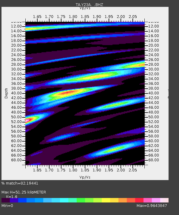
| Estimated Moho Depth: |
51.25 km |
| Estimated Crust Vp/Vs: |
1.60 |
| Assumed Crust Vp: |
6.502 km/s |
| Estimated Crust Vs: |
4.063 km/s |
| Estimated Crust Poisson's Ratio: |
0.18 |
|
| Radial Match: |
82.19441 % |
| Radial Bump: |
400 |
| Transverse Match: |
79.32528 % |
| Transverse Bump: |
400 |
| SOD ConfigId: |
308276 |
| Insert Time: |
2010-06-22 16:44:16.982 +0000 |
| GWidth: |
2.5 |
| Max Bumps: |
400 |
| Tol: |
0.001 |
|

Signal To Noise
| Channel | StoN | STA | LTA |
| TA:Y23A: :BHZ:20100304T22:49:32.55002Z | 8.740421 | 3.2413698E-6 | 3.7084823E-7 |
| TA:Y23A: :BHN:20100304T22:49:32.55002Z | 5.6723294 | 1.5057334E-6 | 2.6545237E-7 |
| TA:Y23A: :BHE:20100304T22:49:32.55002Z | 3.8787875 | 1.1504166E-6 | 2.965918E-7 |
| Arrivals |
| Ps | 5.0 SECOND |
| PpPs | 20 SECOND |
| PsPs/PpSs | 25 SECOND |


