You are here: Home > Network List > TA - USArray Transportable Network (new EarthScope stations) Stations List
> Station H20A Greybull, WY, USA > Earthquake Result Viewer
H20A Greybull, WY, USA - Earthquake Result Viewer
| Earthquake location: |
Northern Chile |
| Earthquake latitude/longitude: |
-22.2/-68.3 |
| Earthquake time(UTC): |
2010/03/04 (063) 22:39:26 GMT |
| Earthquake Depth: |
114 km |
| Earthquake Magnitude: |
6.3 MB, 6.4 MW, 6.3 MW |
| Earthquake Catalog/Contributor: |
WHDF/NEIC |
|
| Network: |
TA USArray Transportable Network (new EarthScope stations) |
| Station: |
H20A Greybull, WY, USA |
| Lat/Lon: |
44.49 N/108.00 W |
| Elevation: |
1236 m |
|
| Distance: |
75.7 deg |
| Az: |
331.859 deg |
| Baz: |
142.37 deg |
| Ray Param: |
0.051250912 |
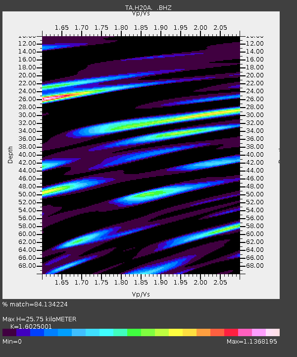
| Estimated Moho Depth: |
25.75 km |
| Estimated Crust Vp/Vs: |
1.60 |
| Assumed Crust Vp: |
6.178 km/s |
| Estimated Crust Vs: |
3.855 km/s |
| Estimated Crust Poisson's Ratio: |
0.18 |
|
| Radial Match: |
84.134224 % |
| Radial Bump: |
355 |
| Transverse Match: |
80.00871 % |
| Transverse Bump: |
395 |
| SOD ConfigId: |
308276 |
| Insert Time: |
2010-06-22 16:49:15.204 +0000 |
| GWidth: |
2.5 |
| Max Bumps: |
400 |
| Tol: |
0.001 |
|
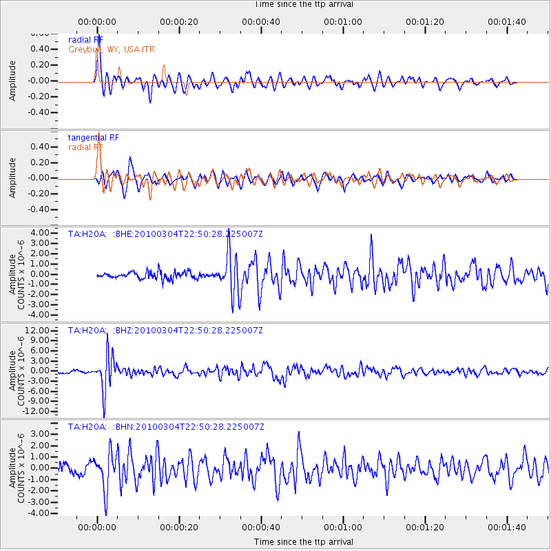
Signal To Noise
| Channel | StoN | STA | LTA |
| TA:H20A: :BHZ:20100304T22:50:28.225007Z | 17.009491 | 5.3573362E-6 | 3.1496157E-7 |
| TA:H20A: :BHN:20100304T22:50:28.225007Z | 3.2396722 | 1.6493701E-6 | 5.091164E-7 |
| TA:H20A: :BHE:20100304T22:50:28.225007Z | 6.0217276 | 2.003311E-6 | 3.3268043E-7 |
| Arrivals |
| Ps | 2.6 SECOND |
| PpPs | 11 SECOND |
| PsPs/PpSs | 13 SECOND |


