You are here: Home > Network List > AU - Australian Seismological Centre Stations List
> Station KMBL Kambalda, WA > Earthquake Result Viewer
KMBL Kambalda, WA - Earthquake Result Viewer
| Earthquake location: |
Kermadec Islands Region |
| Earthquake latitude/longitude: |
-30.4/-176.7 |
| Earthquake time(UTC): |
2023/04/24 (114) 00:41:46 GMT |
| Earthquake Depth: |
10 km |
| Earthquake Magnitude: |
7.3 Mi |
| Earthquake Catalog/Contributor: |
NEIC PDE/pt |
|
| Network: |
AU Australian Seismological Centre |
| Station: |
KMBL Kambalda, WA |
| Lat/Lon: |
31.37 S/121.88 E |
| Elevation: |
370 m |
|
| Distance: |
52.1 deg |
| Az: |
252.194 deg |
| Baz: |
105.941 deg |
| Ray Param: |
0.066995524 |
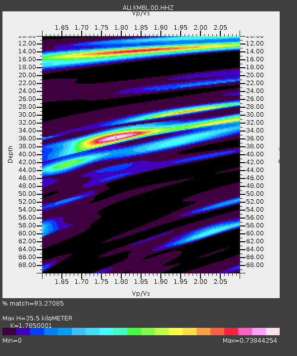
| Estimated Moho Depth: |
35.5 km |
| Estimated Crust Vp/Vs: |
1.79 |
| Assumed Crust Vp: |
6.459 km/s |
| Estimated Crust Vs: |
3.619 km/s |
| Estimated Crust Poisson's Ratio: |
0.27 |
|
| Radial Match: |
93.27085 % |
| Radial Bump: |
252 |
| Transverse Match: |
66.20877 % |
| Transverse Bump: |
400 |
| SOD ConfigId: |
30536071 |
| Insert Time: |
2023-05-08 00:45:01.309 +0000 |
| GWidth: |
2.5 |
| Max Bumps: |
400 |
| Tol: |
0.001 |
|

Signal To Noise
| Channel | StoN | STA | LTA |
| AU:KMBL:00:HHZ:20230424T00:50:24.934998Z | 17.269278 | 3.2130529E-6 | 1.86056E-7 |
| AU:KMBL:00:HHN:20230424T00:50:24.934998Z | 4.285116 | 4.3674183E-7 | 1.01920655E-7 |
| AU:KMBL:00:HHE:20230424T00:50:24.934998Z | 13.99788 | 1.5606453E-6 | 1.11491545E-7 |
| Arrivals |
| Ps | 4.6 SECOND |
| PpPs | 14 SECOND |
| PsPs/PpSs | 19 SECOND |


