You are here: Home > Network List > CC - Cascade Chain Volcano Monitoring Stations List
> Station SHRK Shell Rock, OR, USA > Earthquake Result Viewer
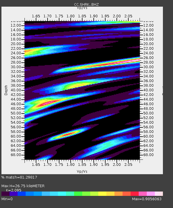
SHRK Shell Rock, OR, USA - Earthquake Result Viewer
| Earthquake location: |
Kermadec Islands Region |
| Earthquake latitude/longitude: |
-30.4/-176.7 |
| Earthquake time(UTC): |
2023/04/24 (114) 00:41:46 GMT |
| Earthquake Depth: |
10 km |
| Earthquake Magnitude: |
7.3 Mi |
| Earthquake Catalog/Contributor: |
NEIC PDE/pt |
|
| Network: |
CC Cascade Chain Volcano Monitoring |
| Station: |
SHRK Shell Rock, OR, USA |
| Lat/Lon: |
45.46 N/121.53 W |
| Elevation: |
1319 m |
|
| Distance: |
90.6 deg |
| Az: |
35.299 deg |
| Baz: |
225.182 deg |
| Ray Param: |
0.041690838 |
| Estimated Moho Depth: |
26.75 km |
| Estimated Crust Vp/Vs: |
2.10 |
| Assumed Crust Vp: |
6.597 km/s |
| Estimated Crust Vs: |
3.149 km/s |
| Estimated Crust Poisson's Ratio: |
0.35 |
|
| Radial Match: |
81.29817 % |
| Radial Bump: |
400 |
| Transverse Match: |
69.62848 % |
| Transverse Bump: |
400 |
| SOD ConfigId: |
30536071 |
| Insert Time: |
2023-05-08 00:48:52.697 +0000 |
| GWidth: |
2.5 |
| Max Bumps: |
400 |
| Tol: |
0.001 |
|

Signal To Noise
| Channel | StoN | STA | LTA |
| CC:SHRK: :BHZ:20230424T00:54:16.880005Z | 0.8422122 | 1.8487113E-7 | 2.1950659E-7 |
| CC:SHRK: :BHN:20230424T00:54:16.880005Z | 2.6462178 | 1.1592712E-6 | 4.3808606E-7 |
| CC:SHRK: :BHE:20230424T00:54:16.880005Z | 0.41505733 | 1.7650238E-7 | 4.252482E-7 |
| Arrivals |
| Ps | 4.5 SECOND |
| PpPs | 12 SECOND |
| PsPs/PpSs | 17 SECOND |


