You are here: Home > Network List > CC - Cascade Chain Volcano Monitoring Stations List
> Station USFR Upper South Fork Repeater > Earthquake Result Viewer
USFR Upper South Fork Repeater - Earthquake Result Viewer
| Earthquake location: |
Kermadec Islands Region |
| Earthquake latitude/longitude: |
-30.4/-176.7 |
| Earthquake time(UTC): |
2023/04/24 (114) 00:41:46 GMT |
| Earthquake Depth: |
10 km |
| Earthquake Magnitude: |
7.3 Mi |
| Earthquake Catalog/Contributor: |
NEIC PDE/pt |
|
| Network: |
CC Cascade Chain Volcano Monitoring |
| Station: |
USFR Upper South Fork Repeater |
| Lat/Lon: |
46.22 N/122.23 W |
| Elevation: |
1342 m |
|
| Distance: |
90.8 deg |
| Az: |
34.42 deg |
| Baz: |
224.689 deg |
| Ray Param: |
0.041675452 |
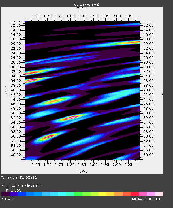
| Estimated Moho Depth: |
36.0 km |
| Estimated Crust Vp/Vs: |
1.61 |
| Assumed Crust Vp: |
6.566 km/s |
| Estimated Crust Vs: |
4.091 km/s |
| Estimated Crust Poisson's Ratio: |
0.18 |
|
| Radial Match: |
91.02216 % |
| Radial Bump: |
400 |
| Transverse Match: |
90.620995 % |
| Transverse Bump: |
400 |
| SOD ConfigId: |
30536071 |
| Insert Time: |
2023-05-08 00:49:00.782 +0000 |
| GWidth: |
2.5 |
| Max Bumps: |
400 |
| Tol: |
0.001 |
|

Signal To Noise
| Channel | StoN | STA | LTA |
| CC:USFR: :BHZ:20230424T00:54:17.73999Z | 0.922636 | 1.7280662E-7 | 1.8729664E-7 |
| CC:USFR: :BHN:20230424T00:54:17.73999Z | 0.9450999 | 3.8835688E-7 | 4.1091624E-7 |
| CC:USFR: :BHE:20230424T00:54:17.73999Z | 1.7802194 | 5.955065E-7 | 3.3451298E-7 |
| Arrivals |
| Ps | 3.4 SECOND |
| PpPs | 14 SECOND |
| PsPs/PpSs | 17 SECOND |


