You are here: Home > Network List > G - GEOSCOPE Stations List
> Station INU Inuyama, Japan > Earthquake Result Viewer
INU Inuyama, Japan - Earthquake Result Viewer

| Earthquake location: |
Kermadec Islands Region |
| Earthquake latitude/longitude: |
-30.4/-176.7 |
| Earthquake time(UTC): |
2023/04/24 (114) 00:41:46 GMT |
| Earthquake Depth: |
10 km |
| Earthquake Magnitude: |
7.3 Mi |
| Earthquake Catalog/Contributor: |
NEIC PDE/pt |
|
| Network: |
G GEOSCOPE |
| Station: |
INU Inuyama, Japan |
| Lat/Lon: |
35.35 N/137.03 E |
| Elevation: |
132 m |
|
| Distance: |
78.6 deg |
| Az: |
322.953 deg |
| Baz: |
140.455 deg |
| Ray Param: |
0.04955439 |
| Estimated Moho Depth: |
39.0 km |
| Estimated Crust Vp/Vs: |
1.60 |
| Assumed Crust Vp: |
6.461 km/s |
| Estimated Crust Vs: |
4.038 km/s |
| Estimated Crust Poisson's Ratio: |
0.18 |
|
| Radial Match: |
94.94865 % |
| Radial Bump: |
400 |
| Transverse Match: |
84.68092 % |
| Transverse Bump: |
400 |
| SOD ConfigId: |
30536071 |
| Insert Time: |
2023-05-08 00:51:20.899 +0000 |
| GWidth: |
2.5 |
| Max Bumps: |
400 |
| Tol: |
0.001 |
|
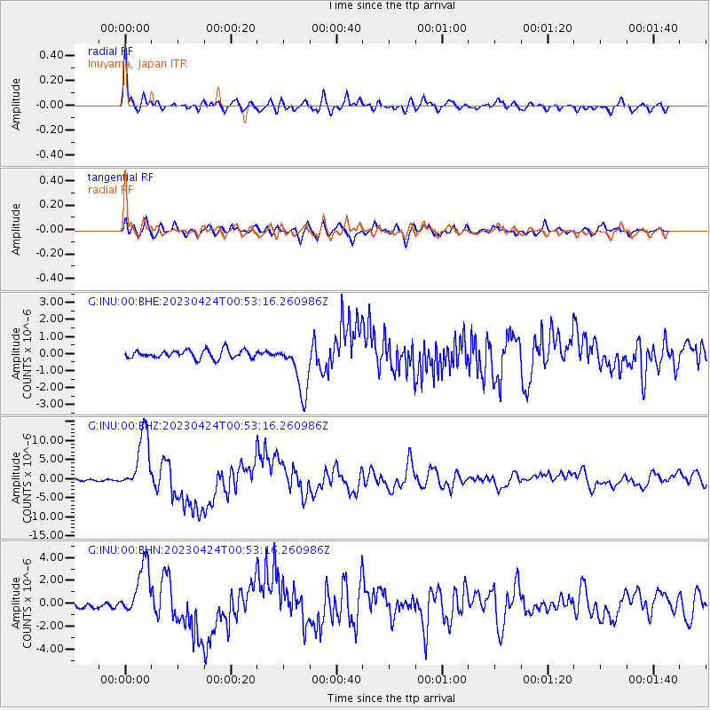
Signal To Noise
| Channel | StoN | STA | LTA |
| G:INU:00:BHZ:20230424T00:53:16.260986Z | 33.945118 | 7.726572E-6 | 2.2761955E-7 |
| G:INU:00:BHN:20230424T00:53:16.260986Z | 10.091758 | 2.3418181E-6 | 2.3205256E-7 |
| G:INU:00:BHE:20230424T00:53:16.260986Z | 6.3389397 | 1.5316909E-6 | 2.4163205E-7 |
| Arrivals |
| Ps | 3.7 SECOND |
| PpPs | 15 SECOND |
| PsPs/PpSs | 19 SECOND |


