You are here: Home > Network List > GM - US Geological Survey Networks Stations List
> Station NMP45 New Mexico Permian - Site# W4S5 > Earthquake Result Viewer
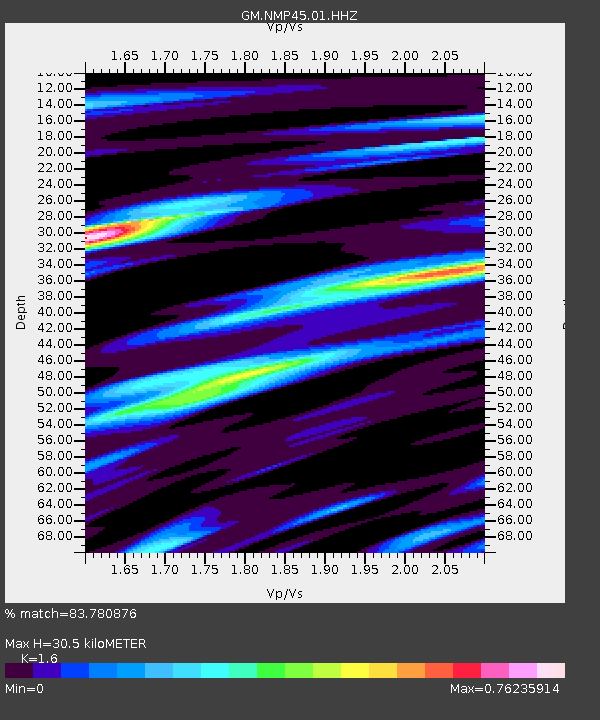
NMP45 New Mexico Permian - Site# W4S5 - Earthquake Result Viewer
| Earthquake location: |
Kermadec Islands Region |
| Earthquake latitude/longitude: |
-30.4/-176.7 |
| Earthquake time(UTC): |
2023/04/24 (114) 00:41:46 GMT |
| Earthquake Depth: |
10 km |
| Earthquake Magnitude: |
7.3 Mi |
| Earthquake Catalog/Contributor: |
NEIC PDE/pt |
|
| Network: |
GM US Geological Survey Networks |
| Station: |
NMP45 New Mexico Permian - Site# W4S5 |
| Lat/Lon: |
32.33 N/103.58 W |
| Elevation: |
1127 m |
|
| Distance: |
93.2 deg |
| Az: |
54.239 deg |
| Baz: |
235.898 deg |
| Ray Param: |
0.04131512 |
| Estimated Moho Depth: |
30.5 km |
| Estimated Crust Vp/Vs: |
1.60 |
| Assumed Crust Vp: |
6.129 km/s |
| Estimated Crust Vs: |
3.831 km/s |
| Estimated Crust Poisson's Ratio: |
0.18 |
|
| Radial Match: |
83.780876 % |
| Radial Bump: |
400 |
| Transverse Match: |
40.370308 % |
| Transverse Bump: |
400 |
| SOD ConfigId: |
30536071 |
| Insert Time: |
2023-05-08 00:51:47.312 +0000 |
| GWidth: |
2.5 |
| Max Bumps: |
400 |
| Tol: |
0.001 |
|

Signal To Noise
| Channel | StoN | STA | LTA |
| GM:NMP45:01:HHZ:20230424T00:54:28.809998Z | 0.59291553 | 1.09838616E-7 | 1.852517E-7 |
| GM:NMP45:01:HHN:20230424T00:54:28.809998Z | 1.3424703 | 8.2213484E-7 | 6.1240445E-7 |
| GM:NMP45:01:HHE:20230424T00:54:28.809998Z | 4.020619 | 7.378991E-7 | 1.8352874E-7 |
| Arrivals |
| Ps | 3.0 SECOND |
| PpPs | 13 SECOND |
| PsPs/PpSs | 16 SECOND |


